 A few months back, I was hiking up Sulphur, still deliberating whether to travel to Mexico. It had been my intention for some time to seek out mountains where I could experience altitudes higher than the summits of the Canadian Rockies. I could go to Colorado or California, but it was still winter in those places and the peaks that were viable required sizable approaches, in some cases on skis. In the Lower 48 I could only reach upwards of 4400m, which didn’t provide the heights needed to prepare me for my future goals.
In Mexico one could accessibly reach altitudes over 5000m and quickly return to civilization. My money would go a lot further; plus it allowed me to escape the deep freeze we’d been experiencing this winter in Banff.
My mind turned to the horror stories painted by the media. Not long ago I swore I’d visit Afghanistan before ever setting foot in Mexico, for I’d rather be kidnapped by radical Islamists who (I presumed) lived by a set of religious morals, as opposed to thugs motivated only by money. I pictured myself held captive by the Taliban, fed and watered, whilst discussing the finer points of religion, whereas in Mexico I imagined my body dumped in a ditch with my throat cut.
In terms of mountains, Mexico was the logical choice, but I couldn’t shake the sense of discomfort. On more than one occasion, including this hike up Sulphur, I had an utter meltdown.
I pleaded, why take “vacations” that upset me, that cause so much turmoil? The reasoning came back that the theme of this stage in my life seems to be about meeting my fears head-on as much as it is about traveling to cool places or bagging peaks.
And when all is said and done, this turmoil and the growth that results from it, is beautiful.
I made up my mind to go. I shot off a few texts to try to wrangle a partner but knew it was last minute and secretly relished the fact when replies came back negative. As nervous as I was about this trip, doing it solo just emphasized the elements of self-sufficiency and other reasons why I’d elected to do this sort of thing in the first place.
I delved into a book on Spanish, refusing to be in the same boat I’d found myself on trips to Italy and France. Flailing through a foreign culture was maybe cute the first time, but I knew it wouldn’t fly trying to climb mountains in Mexico.
I also researched altitude, learning the symptoms of altitude sickness and taking precautions to prevent getting it. As I would be relatively alone with no one to monitor me, it was imperative to be aware of how I felt, to make conservative choices and back off if symptoms presented themselves.
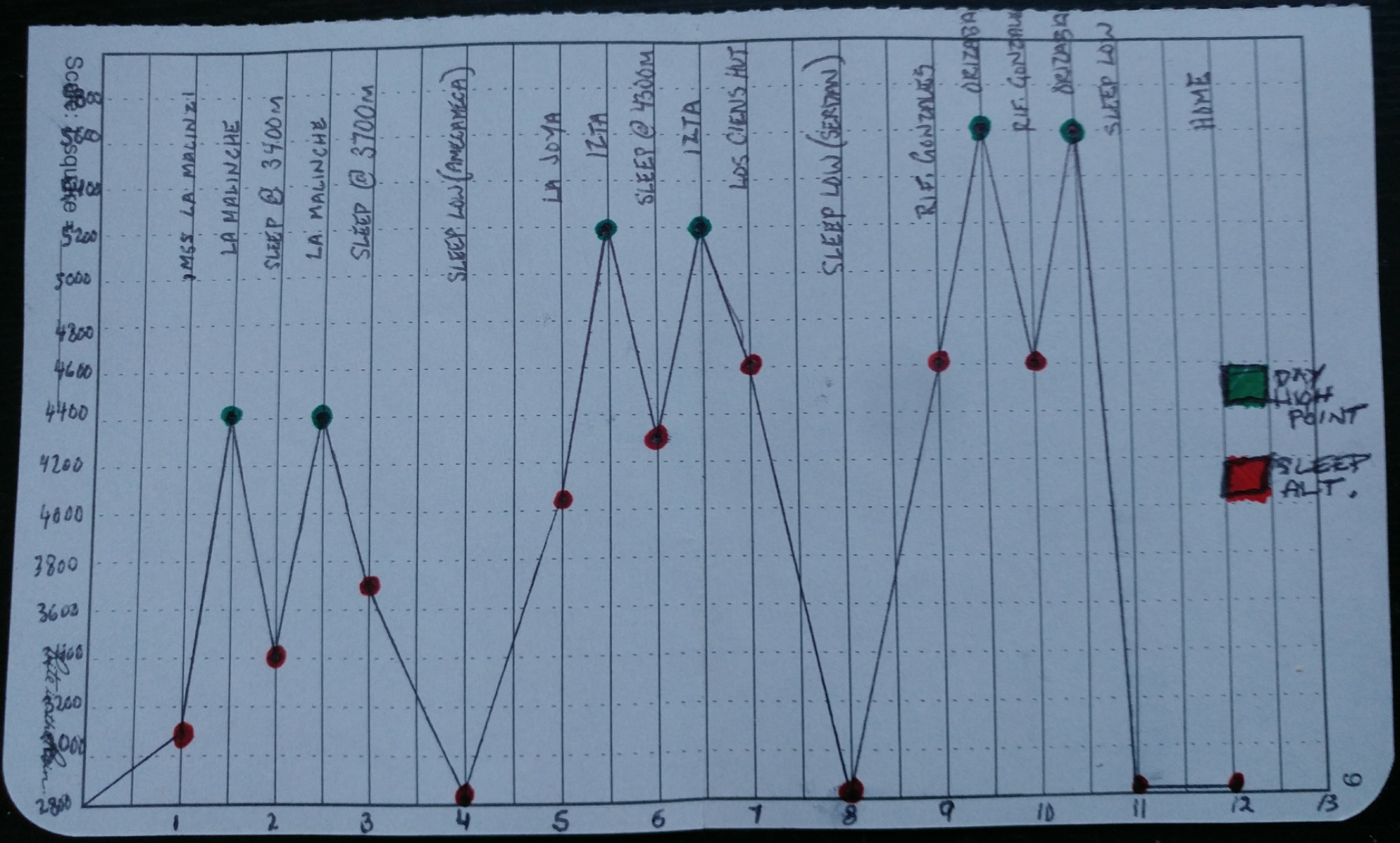
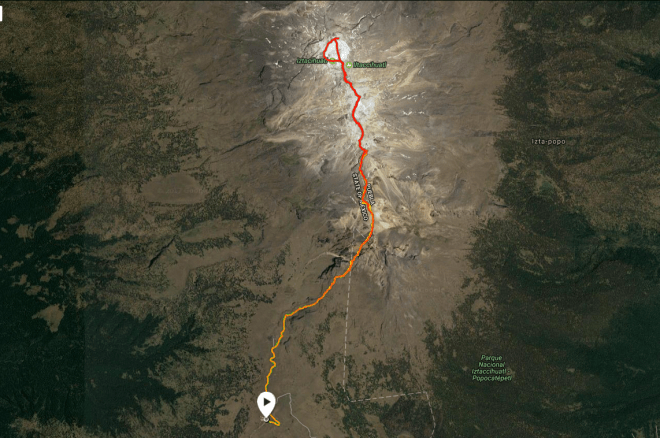
My objectives in Mexico were three mountains (volcanoes actually) increasing in height, with a couple days resting at lower altitudes in-between. As Steve House mentions in his book Training for the New Alpinism, “The body cannot easily do the work of acclimating while remaining up high”. The days spent low (~2500m) would help consolidate gains made at higher altitudes.
Looking back, my experience was wholly positive and as usual my fears were greatly exaggerated. However I don’t for a moment chastise myself for any precaution I took.
It’s easy to develop a narrow view of a broad and diverse country based off a few juicy stories printed by the media. Certainly Mexico has problems with poverty, organized crime and corruption but my experience was of very pleasant people living a simple lifestyle free from the pretense of norteamericano culture.
I was able to record my thoughts day-by-day as a way to occupy myself during the downtime, so I share with you the events of my adventure climbing the volcanoes of Mexico.

16/01/17 – Mexico City to Apizaco
I arrived at Mexico City airport early in the morning and proceeded to weigh down my already heavy backpack with six liters of bottled water. My next objective was to find fuel for my camp stove somewhere in the city.
I had three options and picked the one closest to the bus station. I took a taxi from the airport to Deportes Ruben’s (near the centro historico) which sold several different types of fuel as well as other hiking and mountaineering goods. From there, I traveled to Mexico City’s large and modern TAPO bus station.
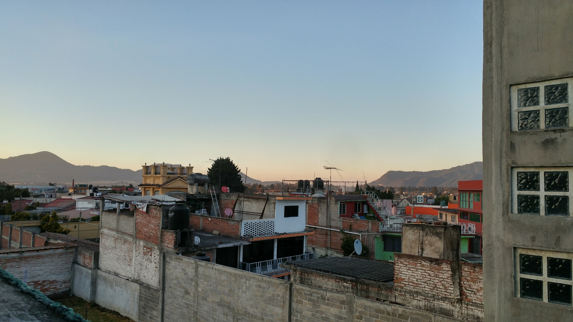
After an hour on the bus, I got off and roved the busy streets of Apizaco, inspecting row after row of identical-looking colectivos for one destined for Centro Vacational La Malintzi, a campground at the base of La Malinche. Another forty-five minutes brought me to the campground where I settled in for the next three nights.
Although everything went smoothly on the first day, I felt way in over my head. The chaos of Mexico City, then Apizaco, certainly contributed, but I was also reconciling my motivations for taking this trip with the reality of actually being there.
The sun set behind the trees and though it was still afternoon, it immediately got chilly. Despite committing so much energy to this trip, now that I was there, my impulse was to go home.
At least there were doggies.

17/01/17 – La Malinche (4461m)
 Putting melancholy sentiments aside, I woke up and started hiking shortly after 8am. Besides the altitude, the trail to the top of La Malinche was easy, its height ideal for acclimatizing for higher peaks.
When I got to the summit, I hung out with a lone Mexicano dude and for awhile we were the only ones up there. Eventually his friends arrived, and after chatting among themselves in Spanish, hollered over at me:
“Amigo! Cannabis?”
I walked over and they handed me the pipe. I could tell by looking at it that it was pretty sad fare compared to what you might find in Canada, but said “gracias” and took a hit. On top of La Malinche, I was officially the highest I’d ever been — the weed contributed little to the situation.
As the crowds and clouds started to converge on the summit, I felt it was time to depart. I hiked back to the campground to eat lunch and play with puppies and stuff.
14.7km | 1369m | 6h24m | Movescount | Strava


18/01/17 – La Malinche (4461m)
 I set my alarm for 4am but didn’t wake up until a half hour later, and had to climb over the campground gate as it was still closed for the night.
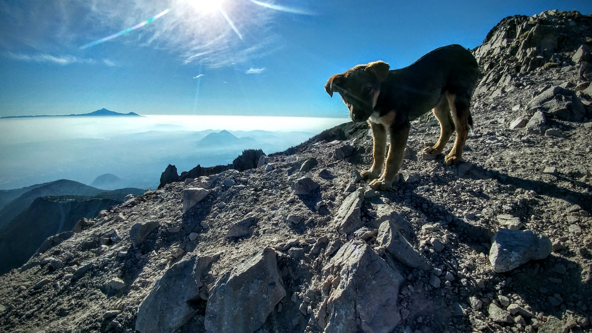
My little canine amiga tagged along, though a full-blown ascent of La Malinche was probably more than she’d bargained for. Numerous times she tried to curl up and go to sleep but refused to get left behind.
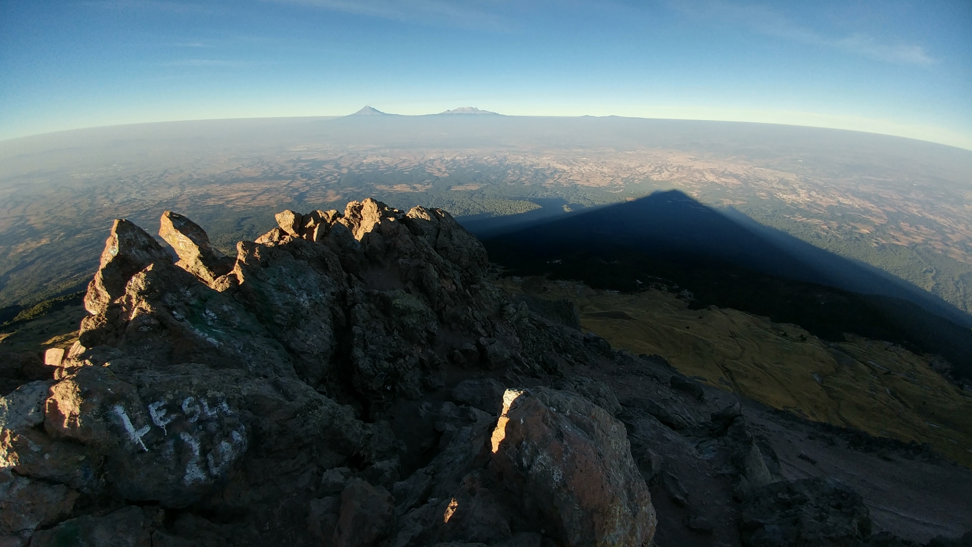
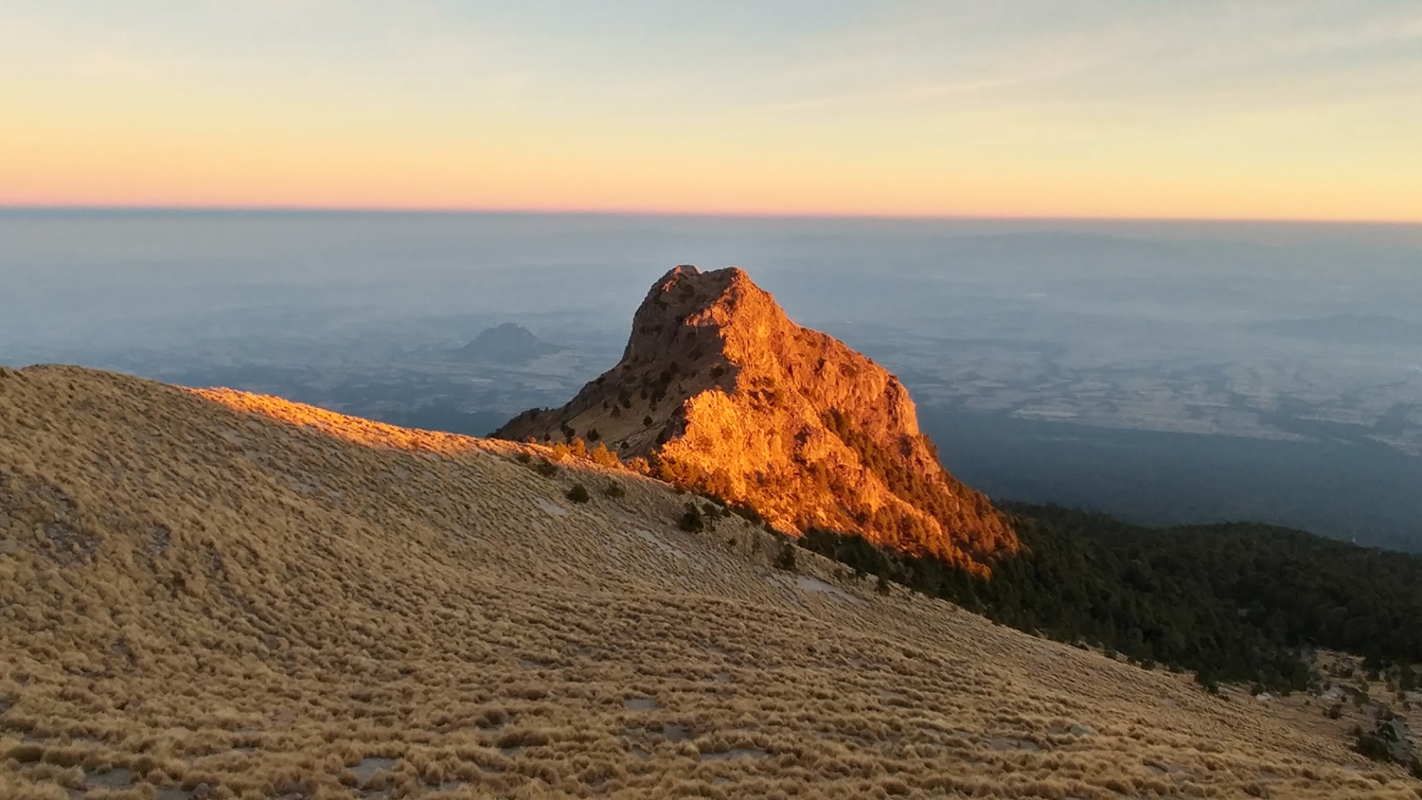
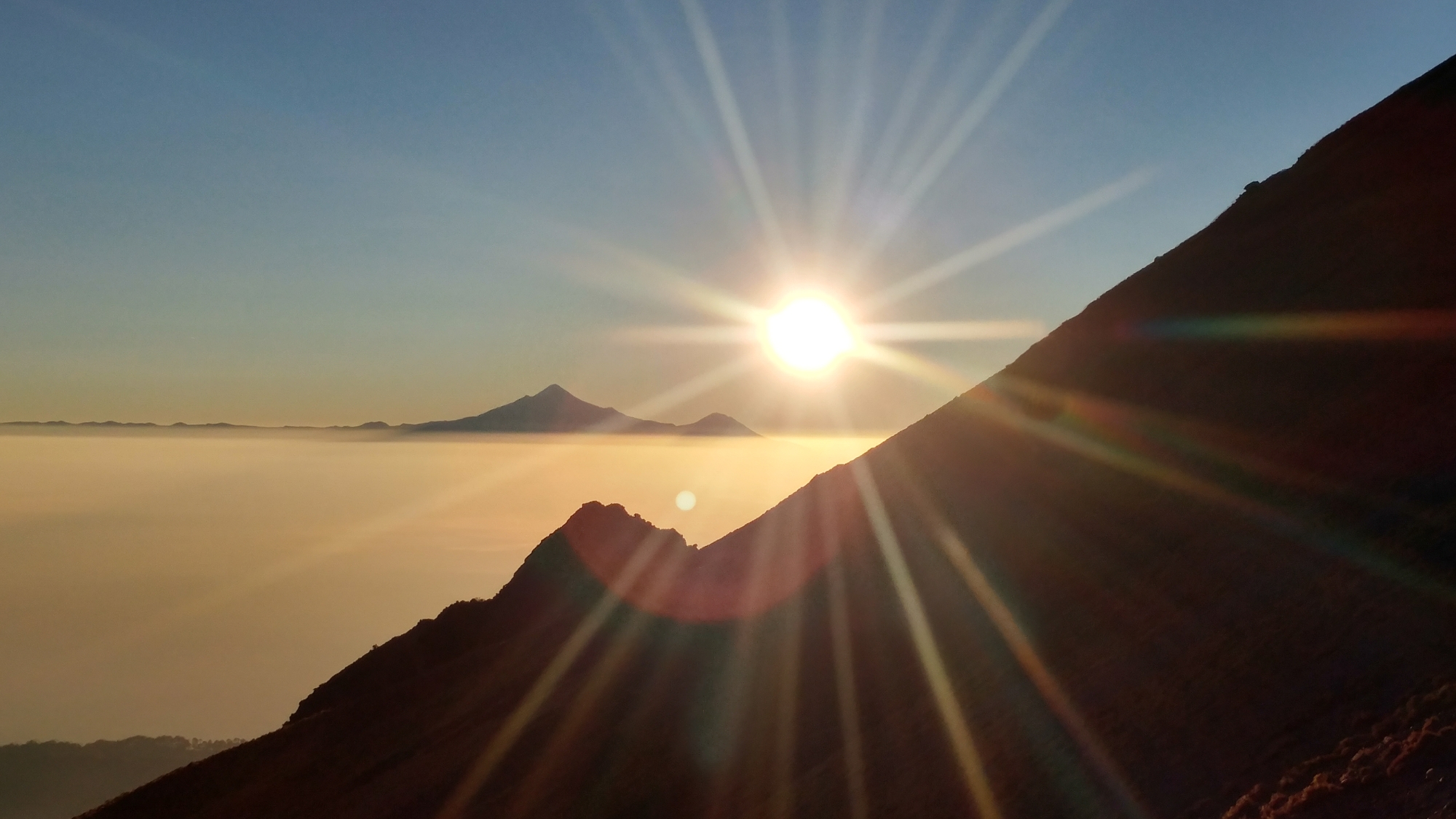
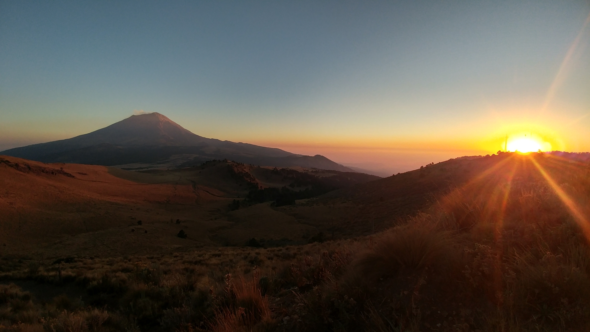
I felt way more sluggish than the previous day. Maybe it was the previous day’s ascent still in my legs, a lack of calories or a lack of sleep, but I was feeling it from the get-go. Hence I was a little late to catch the sunrise from the summit but still saw what I went up to see: epic alpenglow on Popo and Izta and the shadow of Malinche extending all the way to the horizon.
 The ambitious pup followed right until the summit block but wasn’t keen on getting hoisted up the final couple meters of class III which puts you on the summit proper. She curled up along the ridge and waited as I soaked up the sun, the views, the solitude and the altitude this baby volcano provides.


19/01/17 – Amecameca
After another frigid night, I woke up at 7:30am and made coffee. Somehow, an hour and a half wasn’t enough and I was scrambling to pack up my camp and catch the colectivo back to Apizaco.
I traveled back to Mexico City TAPO, ate some fast food (mmm, sodium) and caught the next bus to Amecameca.
I’d heard that getting a ride to La Joya, the starting point for climbing Iztaccihuatl, wasn’t difficult, and taxi drivers would approach as you got off the bus. However, I stepped off the bus and saw no one, just the vacant streets of an unfamilar town.
I walked for a block towards the San Carlos, a hotel popular with climbers, before passing a lingering cabbie who asked me, “La Joya?” I said si but wasn’t sure what time and wanted to check into the hotel first. The driver handed me a business card and I kept on walking.
The San Carlos was located a few blocks from the bus station in the central zocolo. I walked across the square to discover a fleet of military vehicles arrayed around the hotel and the entrance blocked by two soldiers with assault rifles slung across their chests.
I walked up the stairs but they politely informed me there were no rooms available and pointed in the direction of different hotel.
 I checked into Hotel Bonampak for one night and for relatively few pesos got a modest room (it had a hot shower so good enough).
The next step was to get a national park permit and arrange to sleep at Altzomoni Lodge. These were the only bits of red tape involved in climbing mountains on this trip and wasn’t difficult at all. As for Altzomoni, I’d decided to stay at this utilitarian bunkhouse instead of sleeping in my tent at La Joya to avoid freezing my ass off like the first three nights.
I filled out the permit application and made arrangements to sleep at Altzomoni at the Izta-Popo Zoquiapan park headquarters right beside the San Carlos. If only a permit is needed, it can be obtained at Paso de Cortes on your way to La Joya.
I walked back to the bus station to try to organize a lift up to La Joya the next day when I bumped into the same taxi driver I’d spoken to before. I asked if he could take me to La Joya and pick me up two days later; he said it was no problem and would pick me up at ten. If climbing Iztaccihuatl, “Bring tun, chocolate y… tequila,” he said. I told him I’d save the tequila for after.
20/01/17 – La Joya
 Oscar was waiting outside the hotel at twenty to ten. I heaved my pack into the back of his car and we were off, whizzing along country roads bound for the “Sleeping Woman”.
We stopped at Paso de Cortes to get access bracelets and a key to the lodge. After crawling up the dusty road to the communication compound on top of the hill, I rifled through pesos but seemingly didn’t have enough cash. Oscar didn’t appear too concerned but I promised to pay him as soon as we returned to Amecameca two days later.
I’d developed a mild headache from driving abruptly up to the lodge, but went inside, dropped off my stuff, ate a snack, and headed out for a hike to help acclimatize. I chugged water every fifteen minutes and hiked up to the Grupo de Los Ciens hut (4700m) on Iztaccihuatl in about three hours. I poked my head in the hut, which was residence to a few sleeping mountaineers and mice who scurried around my feet.
 Seventy kilometer-per-hour winds conspired to blow me off the mountain and send me sailing down to Puebla. My only course of action was to brace with my poles and move like molasses into the headwind.
Charming tufts atop of Izta and Popo mid-afternoon built into flying saucer-esque lenticular clouds by the time I got back to the lodge. The storms turned into cyclones that whipped through the volcanic rocks of each mountain’s respective summit. Soon it got dark and Altzomoni was engulfed as well.
I looked at the forecast on my phone — showing clear skies and decreased wind — set my alarm and laid it beside me. I went to sleep feeling optimistic that when my alarm went off a few hours later, the skies would be calm and starry.

21/01/17 – Iztaccihuatl (5232m)
I woke up at 1:30am, ate breakfast and got out the door just after two. The skies were clear, the air cool, and the moon’s crescent looked like a little happy face, as my poles click-clacked down the trail to La Joya.
I caught up to a bunch of my hut-mates who’d left shortly before me then slogged solitarily into the darkness. I made good time up to Los Ciens despite getting a little disoriented in the jumble of rocks below the hut.
The wind was no better than the previous day and if anything, worse. After reaching the hut, I decided to take the couloir on climber’s left to gain the rodillas (knees) rather than the trail that goes directly up the slope.
The path was a little indistinct to find in the dark, but enough tiny cairns existed to guide me into a channel where the way became obvious. As I picked my way through the rubble, I saw headlamps emerging from the hut.
It took more time and effort to reach the top of the knees than expected and I topped out relieved I was done the slog up the gully. But one challenge was replaced by another as atop the exposed knees the wind was at its worst, and as the sun hadn’t risen, I couldn’t see a thing.
The wind alone was sufficient to make me want to bail and it was easy to say, “Oh well, not today Izta.” I huddled behind a concrete pillar belonging to the old hut which ironically was destroyed by weather. I thought it would be safer to wait for the sun than try to find my way back down the gully I’d grovelled up in the dark and looked at my watch: 5:51am… I still had an hour until sunrise.
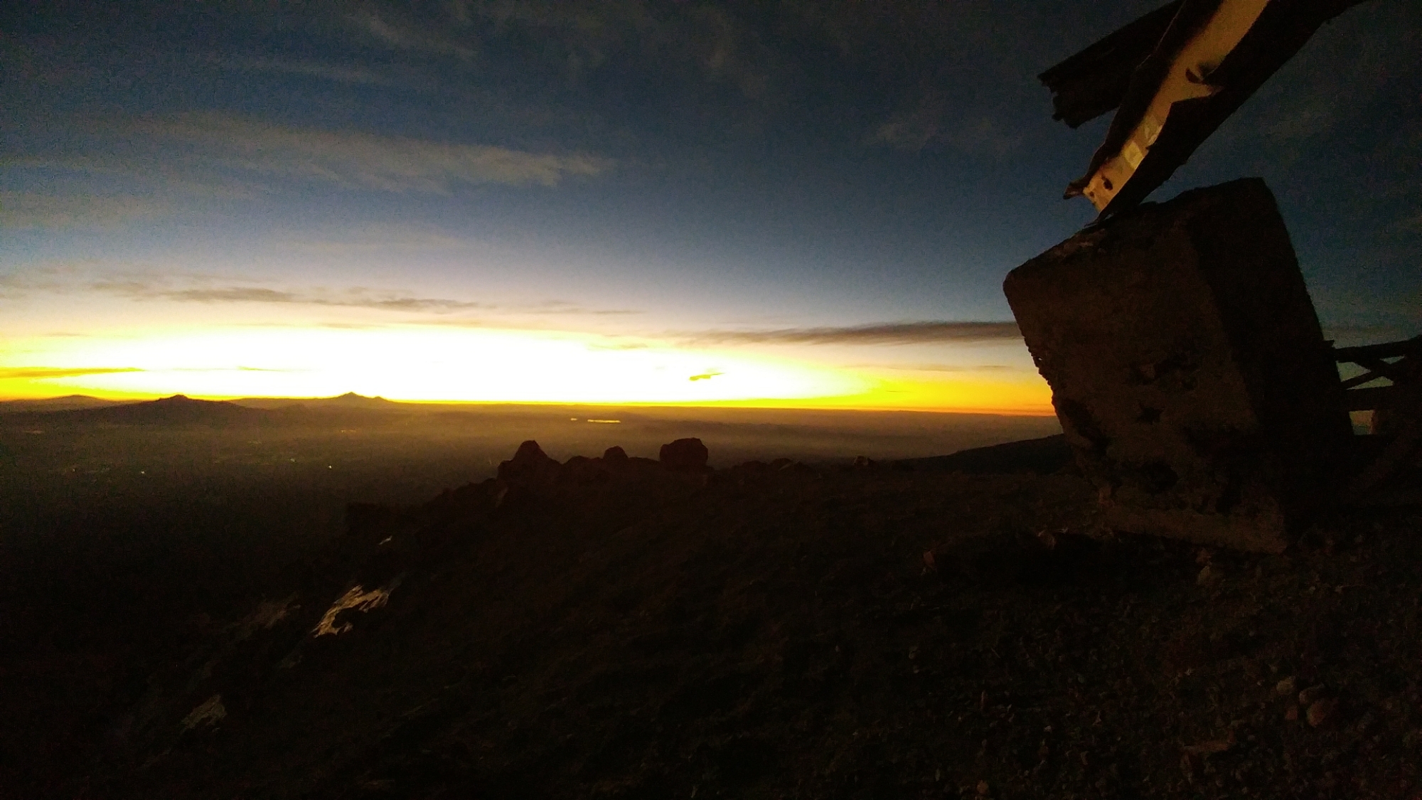 Wind usually blows in one general direction providing reprieve on the lee of some boulder or other large object, however it seemed the wind gusted from every angle, making nowhere remotely comfortable. I squatted in a ball with my arms around my knees as volcanic sand, hoisted by the wind, scoured the surface of my Gore-tex hood. The steel girders of the ruined hut creaked and groaned.
At last the horizon started to glow and lit the sleeping woman with rose-colored light. I saw the series of peaks and ridges and the faint path that sneaked through the scree from the summit I was huddling on, up to the next one. I’d intended to descend as soon as the sun came up — and spent the last hour bemoaning my situation — but with the sun dawned enough confidence for me to at least give it a try.
 At 6:51am I descended the third-class step off the knees and worked my way up to the ridge. I growled as the wind froze my face but it wasn’t long before I was staring across the belly glacier and digging out the Microspikes. The surface of the glacier was like a dry icefield covered in tiny penetentes. Ice crystals sheared off and sifted around my feet as I walked.
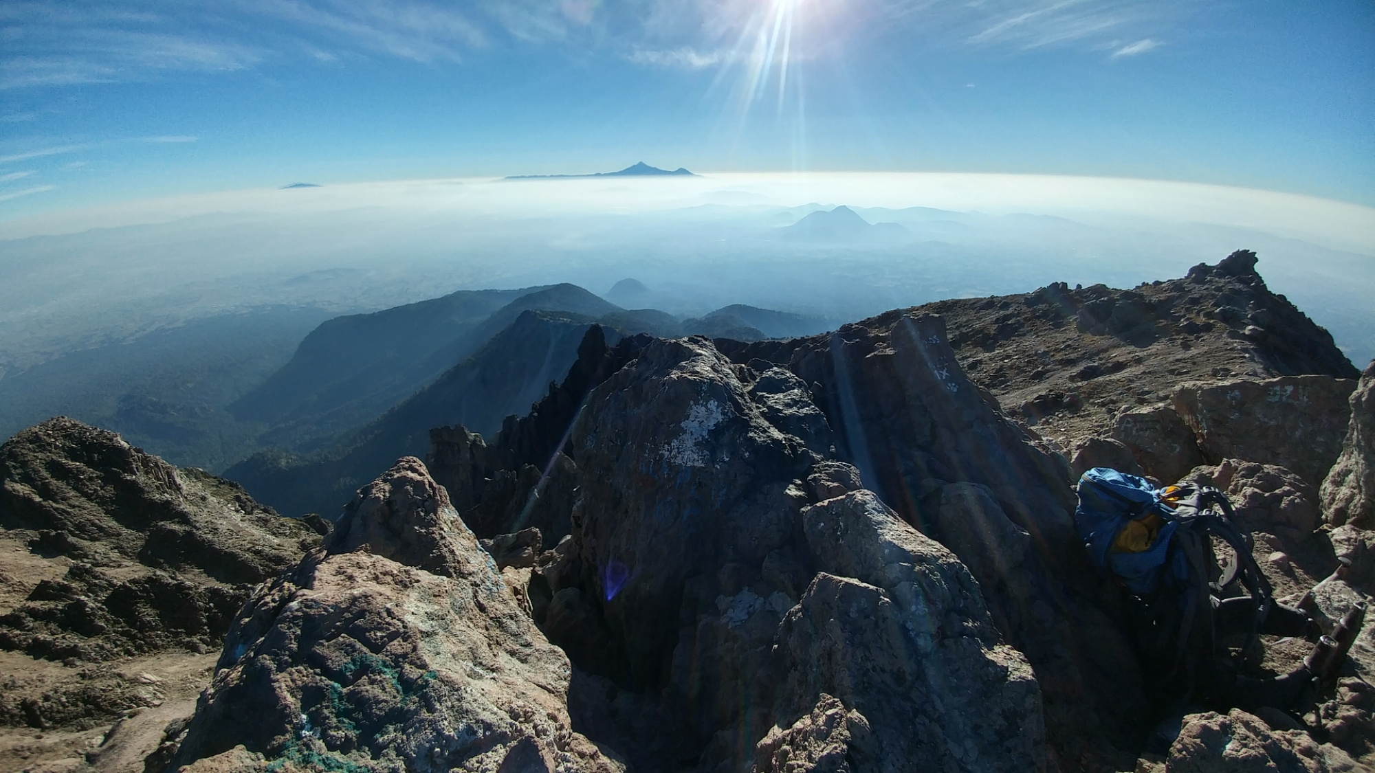
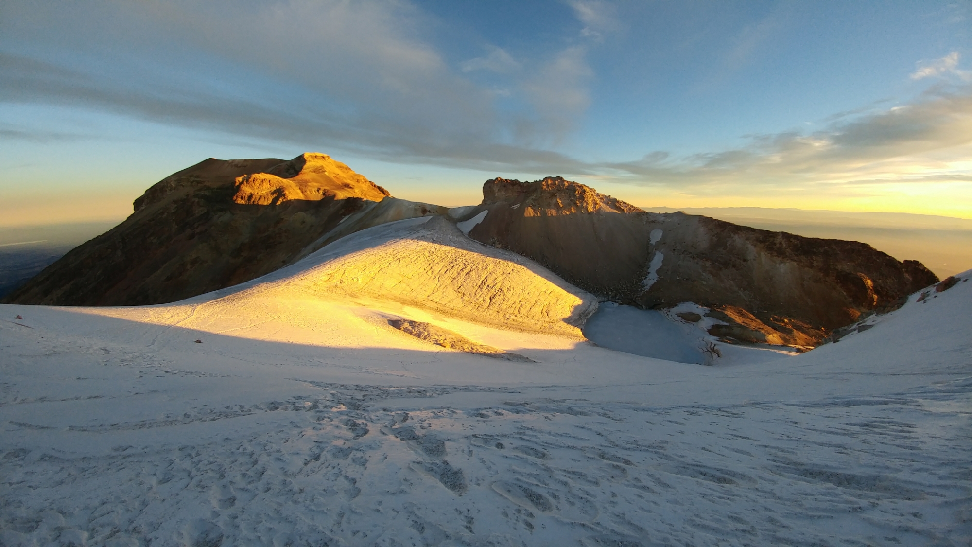 After crossing the glacier, I tagged a series of false summits before reaching the real ones. I emerged onto a high plateau containing another icefield, ringed by a number of modest bumps. This icefield covered the volcan’s crater and these were its highest points, the pechos (breasts).
I came to a mound of dry earth on the west side which I assumed was the highest point. When I got there however, there was no marker besides a tiny stick and another peak at the far end of the icefield looked higher and had a cross on top. Realizing this wasn’t the true summit, I marched across the icefield to the mountain’s highest point.


 I arrived at the summit but wasn’t any warmer and was still getting hammered by the wind, thus my experience was made brief by the feeling of extreme discomfort. Though somewhere deep inside I was stoked to be there, the selfie I took depicts a person not having fun at all.
 The descent went smoothly although I continued to get battered by the wind, especially at any sort of saddle such as the belly glacier, where the wind was channeled by the surrounding peaks.
 I didn’t encounter anyone else along the route until I got back to the rodillas where a bunch of mountaineers were lingering around the ruined hut, just as I had, debating whether to brave the wind. By the second portillo the weather became tolerable and I began to encounter a variety of folks: families out for a dayhike; trail runners picking their way up to the hut; montanistas on their way back from Los Ciens stopped to have a morning snack.
In many ways, that hour spent shivering in the dark was one of the highlights of the entire trip and vastly more rewarding than if I’d climbed Izta on a calm, sunny day. This is definitely an experience I’ll be able to call on for perspective when faced with challenging situations in the future.
19.8km | ~1300m | 8h46m | Movescount | Strava
22/01/17 – Amecameca
 I walked down to La Joya to meet Oscar and after twenty minutes thought to look around the parking area, which was inundated with the vehicles of weekend warriors. I located him standing on a small hill, searching for me on Iztaccihuatl with binoculars.
We drove down to Paso de Cortes where Oscar strongarmed the park staff to return a $100 peso deposit I didn’t know they took. We walked outside and I thanked him; he nodded and gestured with a couple blows to the chin.
We got back to town went to the bank so I could pay him. I handed Oscar a healthy sum, appreciative for his congeniality and not leaving me stranded when my pesos ran dry. I gorged myself on a torta, guzzled a cerveza, checked back into the Bonampak (the San Carlos was still occupied by soldiers) and got lost in the market.
The market swells one-hundred times in size on the weekend, or so I learned upon returning to Amecameca. For blocks I squeezed past hundreds of people engaged in various acts of buying and selling, cooking and eating, and returned home with a veritable bounty, from lychees to pizza to expired Indian cigarettes.
23/01/17 – Ciudad Serdán
I woke up at six to try to get to Ciudad Serdán, — the jumping-off point for my final mountain — early. While the bus left Amecameca before the sun came up, the bus to Serdán didn’t leave Mexico City till sometime in the afternoon, so I sat around TAPO listening to the Enormocast.
Google Maps said the drive supposedly takes three hours but the bus took closer to five, fighting our way out of Mexico City, then stopping at a series of small towns on the way to Serdán. Thus I didn’t arrive until nearly seven p.m.
I was anxious to check into the hotel and arrange a ride up to Orizaba the next day. As I hadn’t actually booked any hotels ahead of time, I was running the same risk I encountered at the San Carlos in Amecameca.
I checked into Hotel Monte Carlo for two nights and mentioned to the manager I intended to find a taxi to take me to the south side of Orizaba. She replied something to the effect that it couldn’t be done. “Atzitzintla” she said, which was another town a half-hour down the road.
I took her response as groundless pessimism, and with my mind firmly set, went to find a taxi to take me there.
 I walked to the bus stop where a bunch of taxis were waiting. I approached the first one I saw and in broken Spanish explained I was looking for someone to take me to the Orizaba/Sierra Negra col first thing in the morning, wait for me to climb Orizaba and bring me back when I was done. The driver thought about it for a minute and with a swaggle of his head replied, “Sure, no problem”.
I verified the various components of the arrangement to make sure we were on the same page: He would pick me up at 6am? Si. Wait while I climb? Si. Drive me back to Serdan? Si.
Cuanto cuesta? 600 pesos. It was a hell of a deal but I shook his hand and said I would see him in the morning.
Content that I’d made a relatively complex arrangement using my shoddy Spanish, I trotted off to Soriana to procure the final implements for an ascent of Pico de Orizaba the next day.
24/01/17 – Ciudad Serdán, continued…
 I woke up at 5am, made some breakfast, went down to the hotel lobby and waited. For a half hour I waited but the taxi never turned up.
Disappointed, I went back to my room but reasoned that this happened for some meaningful purpose, like things often do on trips for me. And while I didn’t feel like sticking around at 2500m another day, I didn’t really have another choice.
I headed into town, my first mission to procure coffee, my second to procure a ride to the saddle a.s.a.p., as my weather window on Orizaba was closing in a couple of days.
I spent most of the morning trying to arrange a ride but soon learned the taxis didn’t have enough power to make it up the road at 4000m. My whole plan to climb Orizaba from the south side was dependent on a misunderstanding I had made in presuming a cab could drive me to the col.
 After asking the third driver, I sat down on a bench in the zocolo feeling pretty let down. I started considering a few bolder/stupider options (such as walking from Serdán — “Better start walking!” I said) but it was obvious I wasn’t prepared for that kind of endeavour.
As my final ditch, I went back to the hotel and asked if they knew anyone with a truck that could do it. The woman behind the desk pulled out a folder, ran her finger down a list, picked up the phone and — well, it wasn’t that easy but it was a start. By two in the afternoon, we’d tentatively arranged for a man named Hugo to drive me up to Orizaba the following day.
Hugo stopped by with his father to talk about the specifics. I estimated taking nine to twelve hours and he agreed to wait while I climbed. I explained I had a helmet (genuinely required), crampons (I had Microspikes — not needed), poles not a piolet… And tried to explain to Hugo’s dad why I had no need for a harness. I’d inspected the south side of Orizaba via webcam every day for the past few months and knew there wasn’t a flake of snow on it. I seemingly knew more about conditions on the mountain than they did.
I said I wanted to arrive at the saddle no later than 7am in order to avoid the ordeal on Iztaccihuatl. Hugo typed out a response on my phone and hit “translate”: “At the time you want to go out of here, you suggest at 6 am”.
I agreed to be ready and said I’d meet him outside at six the next morning.
25/01/17 – Pico de Orizaba (5636m)
 Once more, I woke up at five, ate some breakfast, went down to the lobby and waited. Right at six, Hugo’s Jeep Cherokee came roaring along the otherwise silent streets and stopped in front of the hotel.
The trip to the saddle took a little over an hour and was passed mostly in silence, besides me prying from Hugo that he was indeed a mountain guia as evidenced by the stickers on his truck. We passed through a couple increasingly spartan farming villages as a faint glow appeared above the fields through my window to the east.
We turned onto the road to the saddle, which was surfaced for a few hundred meters with brick, then dirt and rocks.
“A taxi would’ve gotten owned by this”, I thought.
 At the top of the pass I expected Hugo to drop me off, but he kept on driving up the rugged 4×4 track towards the hut at the bottom of Orizaba’s south face. A half-kilometer from the hut the road became too rough, even for his Jeep. I asked Hugo if he wanted me to start walking but was already pulling over and simply said, “yes”.
I started chugging up the hill so Hugo wouldn’t be too worried but, truth be told, it took a good fifteen minutes to feel warmed up. Having sat around in town for the past three days, I was worried my acclimatization might be totally shot but I didn’t feel AMS symptoms, I just felt slow.
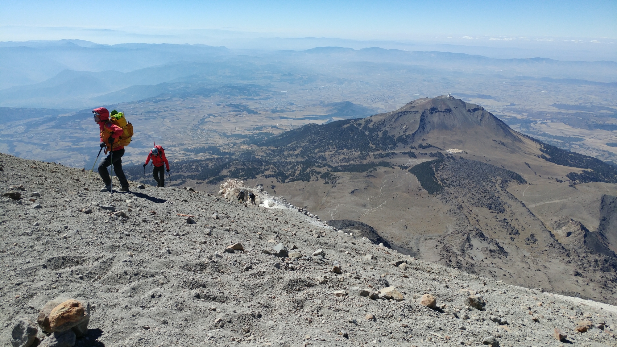
 From the firetruck-red Fausto Gonzales Gomar hut at 4700m, one follows a well-worn trail through the rocks that tromps up to the base of Orizaba’s lado sur. I followed a footpath that started ascending the scree slope east of the bouldery ridge.
The scree wasn’t bad at first — granted I’m seasoned by the worst Canadian Rockies fare — but it soon became interminable. There was a traverse off the slope higher up but I didn’t want to wait that long; the ground was sliding under every footstep, so I clambered over to the ridge and started scrambling through the boulders.
From down near the rifugio, I’d spotted a party two-thirds of the way up the mountain, easily identified by the bright orange of someone’s mountain apparel. By the time I reached them, they’d barely moved.
 They asked “Que tal?” and I joked, “muy bien“, feigning (not really) hyperventilating and/or a heart attack. The momentary contact with other humans was a pleasant reprieve from the incessant slogging. Alhough I managed to move consistently, I could only actually hike or climb for a handful of moves before I had to stop to catch my breath.
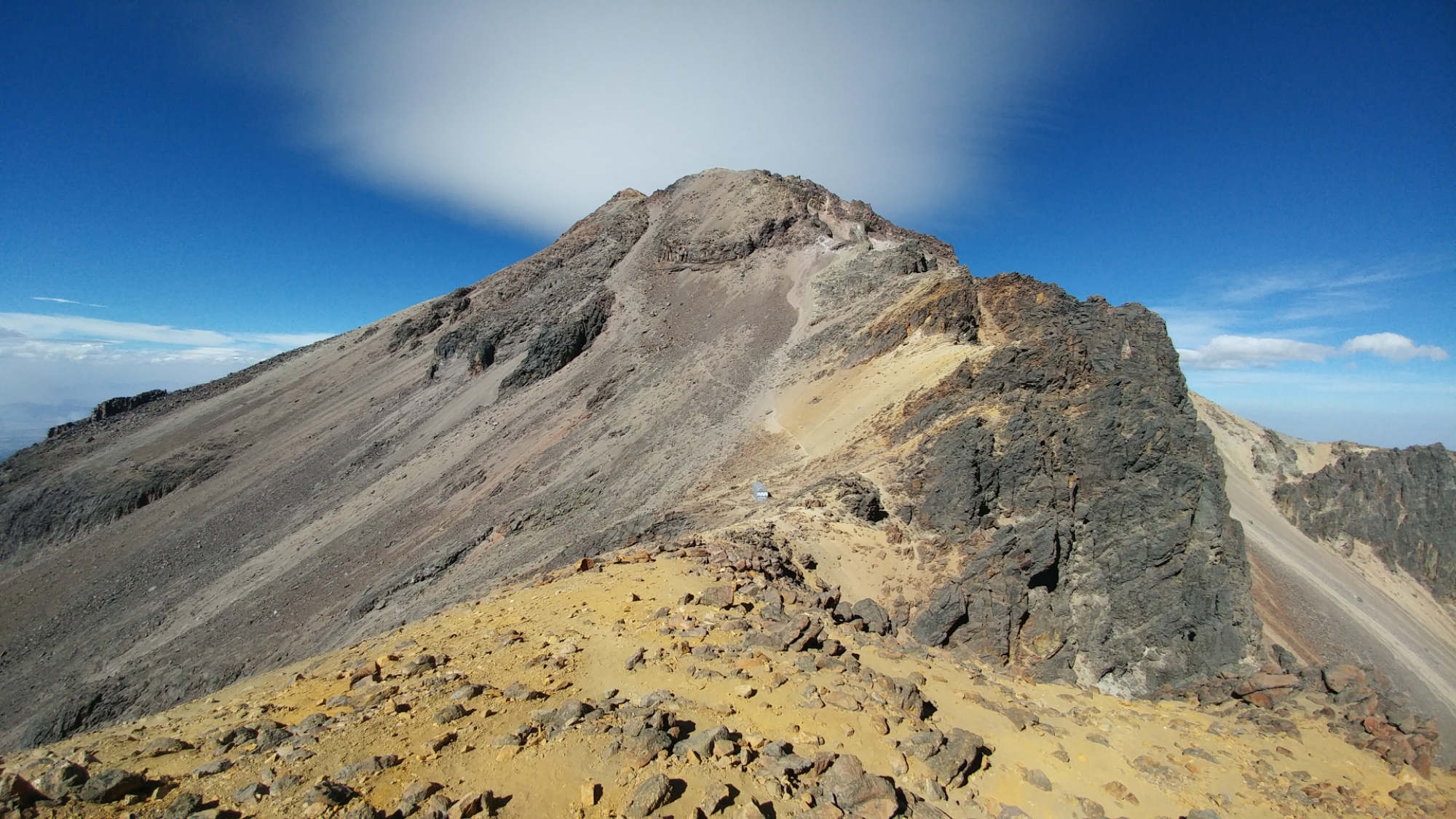
At 5400m, the convenient ridge came to an end and I was faced with an expanse of chalky white scree before reaching the “pulpito”, a rock tower at the top of the route. The ruta sur followed an aesthetic curve from the saddle to the summit, but here that curve ramped up and became chaotic like the whitecap of a wave.
I took a few steps and found it almost impossible to avoid kicking down rocks. I take pride in being adept in this sort of terrain but it was testing the limit of any skill I thought I had.
I premeditated each move, from semi-solid rock to semi-solid rock, which would shift in the mounds of scree when I put any weight on them. I mused half-philosophically whether I’d rather have rocks knocked down on me or be responsible for killing someone in the party below… before grimly electing that I preferred to be above.
I was getting annoyed, feeling it was irresponsible to bring clients up this technically easy but objectively hazardous route, which was for all intents and purposes a shooting gallery. As it was, I managed to knock most of my debris into the gully east of them and quickly scrambled up the side of the pulpito and out of sight.
 Crawling around climber’s-left of the pulpito I discovered the remains of a small crashed airplane which provided the best handholds on the entire route. A small field of penetentes provided more things to hold onto, unless one happened to snap off.
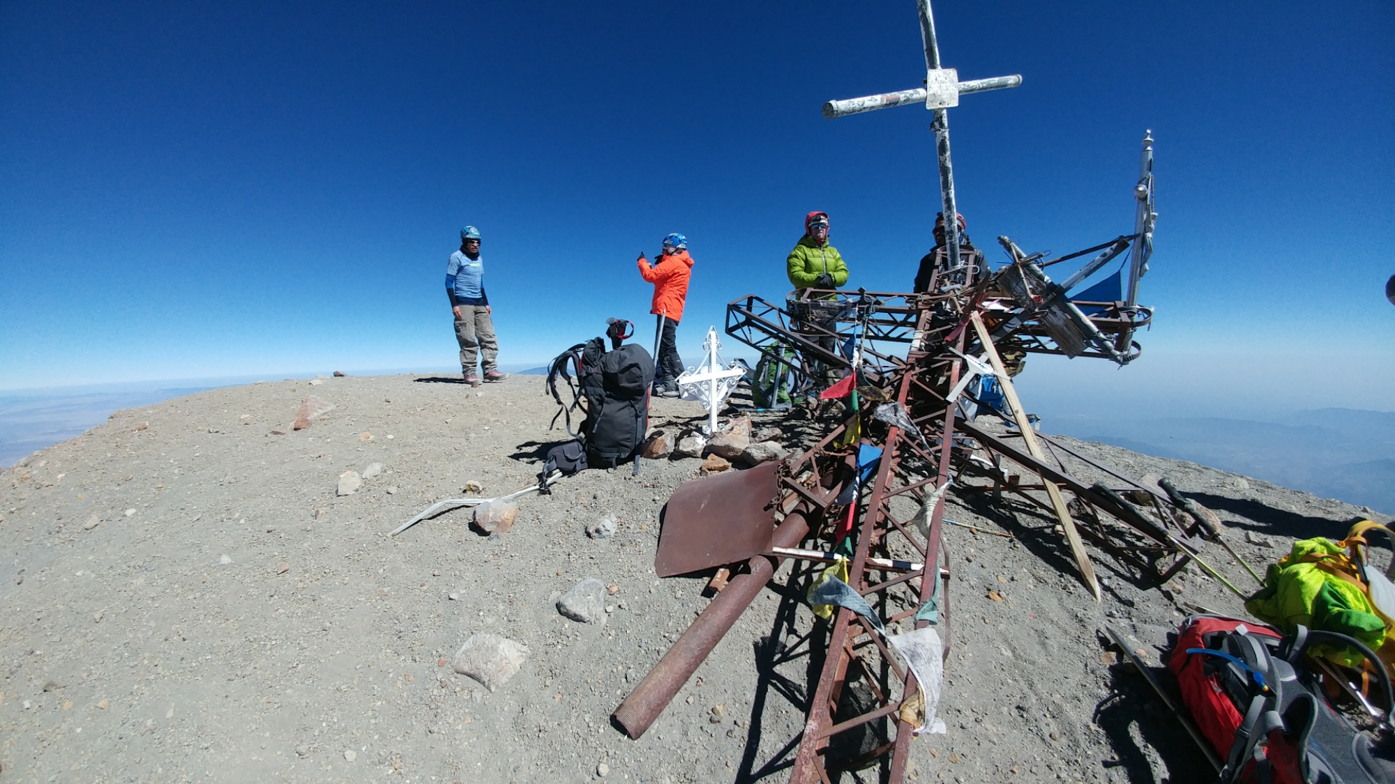
Atop the pulpit, one can see the summit cross and from there, it’s only a short distance to reach the top of Orizaba.
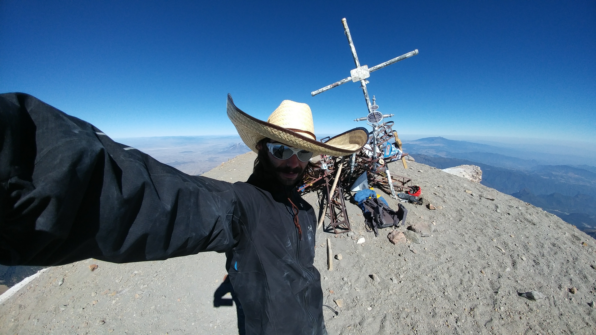
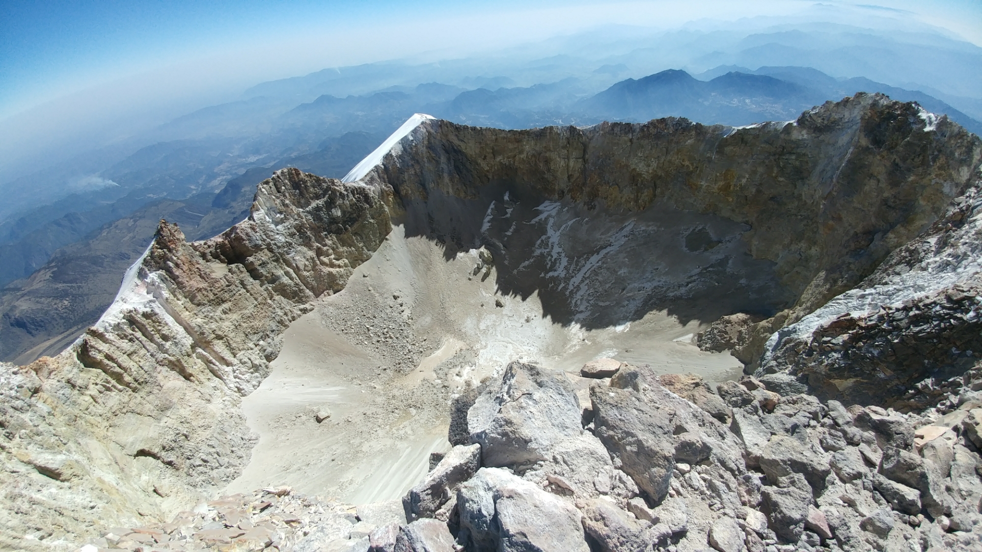
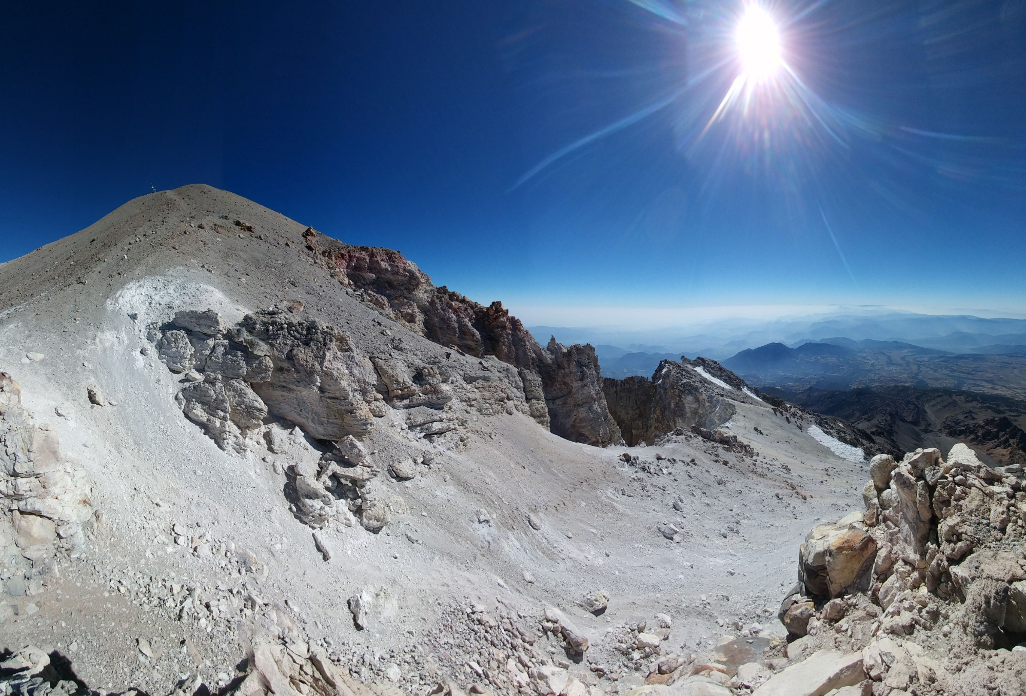 I got to the summit and no one was there. I’d expected to meet a mob of mountaineers who’d come up the north side but I was alone to take in the 360° view of Mexico. The weather was pleasant besides a cold wind that whistled through the mass of steel on the summit adorned with prayer flags, crucifixes, and other objects non-religious in nature. Behind, El Pico’s crumbling caldera yawned.
After hanging out for an hour, members of the guided group started to appear. I apologized for kicking rocks on them but they seemed unfazed and we all exchanged congratulations. The group contained two Americans, the first gringos I’d met on this trip, but everybody spoke English, so it was nice to not struggle to make conversation for once.
By this point I was getting pretty cold, so I took a group picture and left them to enjoy the same solitude I’d been able to.


 During my approach, I’d seen a perfect line of light gray scree descending from the summit all the way to the rifugio at 4700m. This appeared to me like the perfect descent and I was anxious to try to ski it in my runners on the way down.
 I said adios, tightened my sombrero and dropped off the summit majestically but the hard-packed slope was covered in a fine layer of rubble and my attempts to ski resulted in me spinning, sliding and swearing. Below the pulpit, it became easy to plunge through waves of soft, pillowy scree. I plummeted a thousand meters in a half-hour, giggling and gasping for oxygen all the while. Sure, I had a small mountain of rocks in my sneakers when I was done, but gaiters are for wimps 😉
 A short traverse brought me over to the rifugio and back to Hugo’s Jeep, where I found him waiting on top of a huge boulder. Five hours and one minute after leaving I’d returned, dusty and deliriously happy.
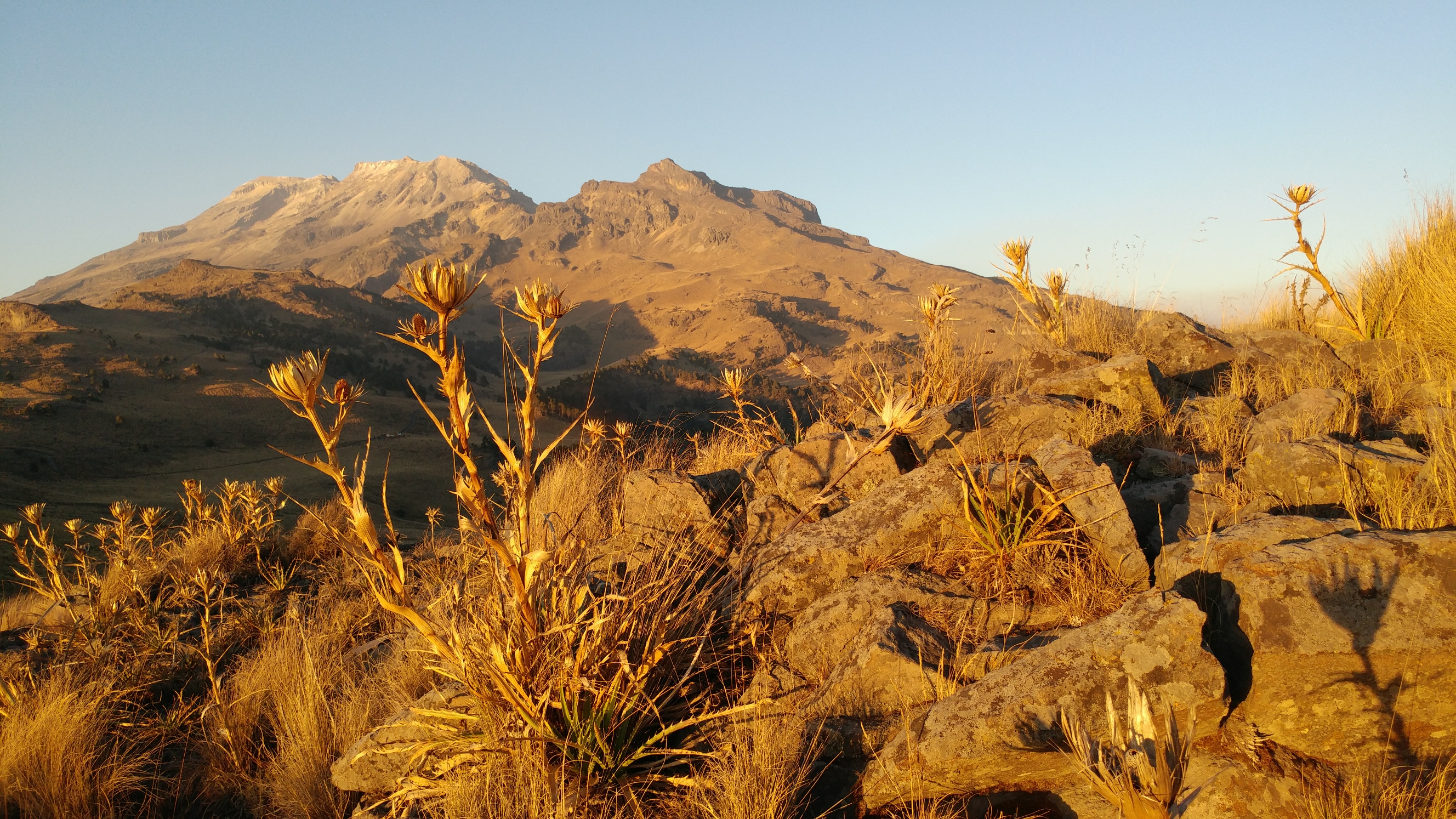
 Pico de Orizaba was supposed to be the climax, the final test of this trip, but felt anticlimactic while climbing it. After the ordeal on Iztaccihuatl, the ascent of Orizaba felt fairly easy, lazily scrambling over boulders on a calm, sunny day. However I won’t deny that Orizaba loomed in my mind as a big challenge, a feeling that wasn’t reduced when I saw it from Malinche for the first time earlier that week.
The challenge of climbing the south side of Orizaba had little to do with climbing and more with the logistics of getting there. As Aleister Crowley wrote in his Confessions: “We had intended to finish our programme by climbing Citlatepetl; but there were difficulties about mules and none about the mountain”.
Arranging the means of supporting one’s mountain goals; building a (hopefully accurate) mental map from scraps of beta and information gleaned from books and the internet — these to me are important components of going on big adventures. As one gets into bigger or more remote mountains, red tape and the hurdle of organizing transportation and porters seems almost as big a challenge as the mountains themselves. It thus appears helpful to be as skilled in this capacity as one is as a mountaineer.
6.9km | 1125m | 5h01m | Movescount | Strava

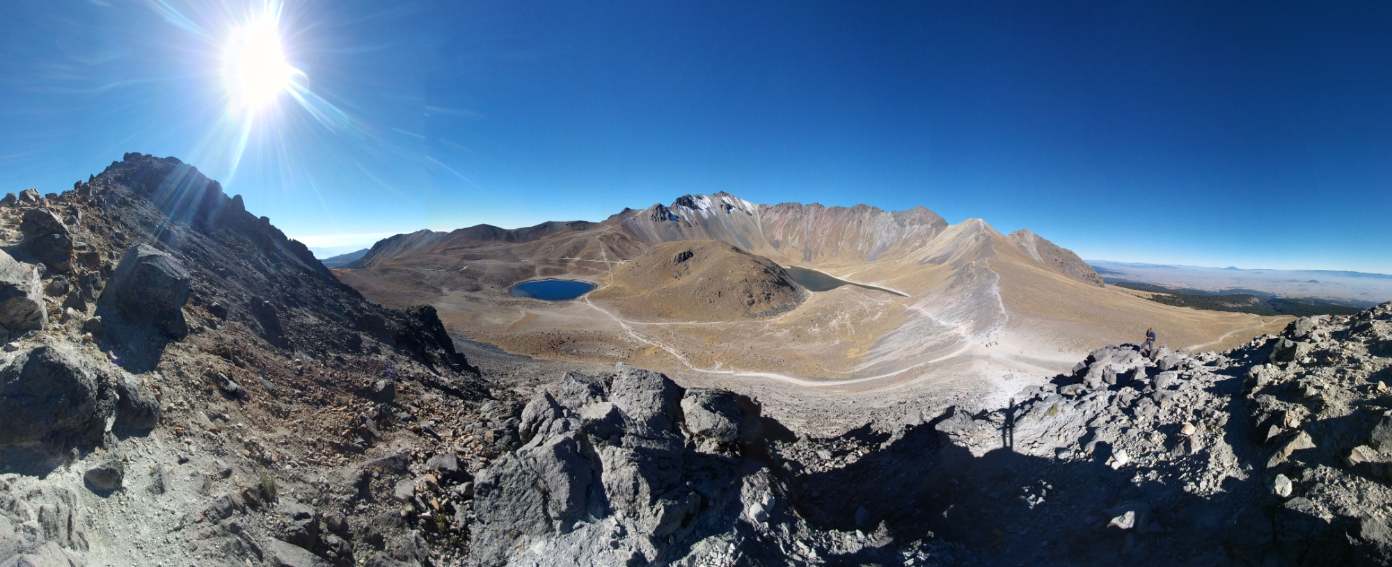
27/01/17 – Nevado de Toluca
You might think after Orizaba I’d be satisfied, but I’d hardly finished dumping the scree out of my sneakers when I started thinking about another volcan. I was ahead of schedule and had two days to kill, so rather than visit cultural sites like a normal person I elected to camp in a crater instead.
I left the Monte Carlo early in the morning and traveled back to Mexico City TAPO. I caught a cab to Observatorio bus station on the west side of the city and from there bussed to Toluca.
The nevado was further from town than I’d imagined and the taxi driver was asking a hefty fare to take me up there and bring me back, but it was the end of my trip and I was resigned to pay for one last experience.
The driver had lived in Chicago for a few years so we talked in English about a variety of subjects, not least the trainwreck of American politics. As we came around the curve of the dusty road we happened on the sight of two people whose double backpacks — overloaded trekking bags on the back, daypacks on the front — immediately marked them as free-spirited-hippy-traveler types.
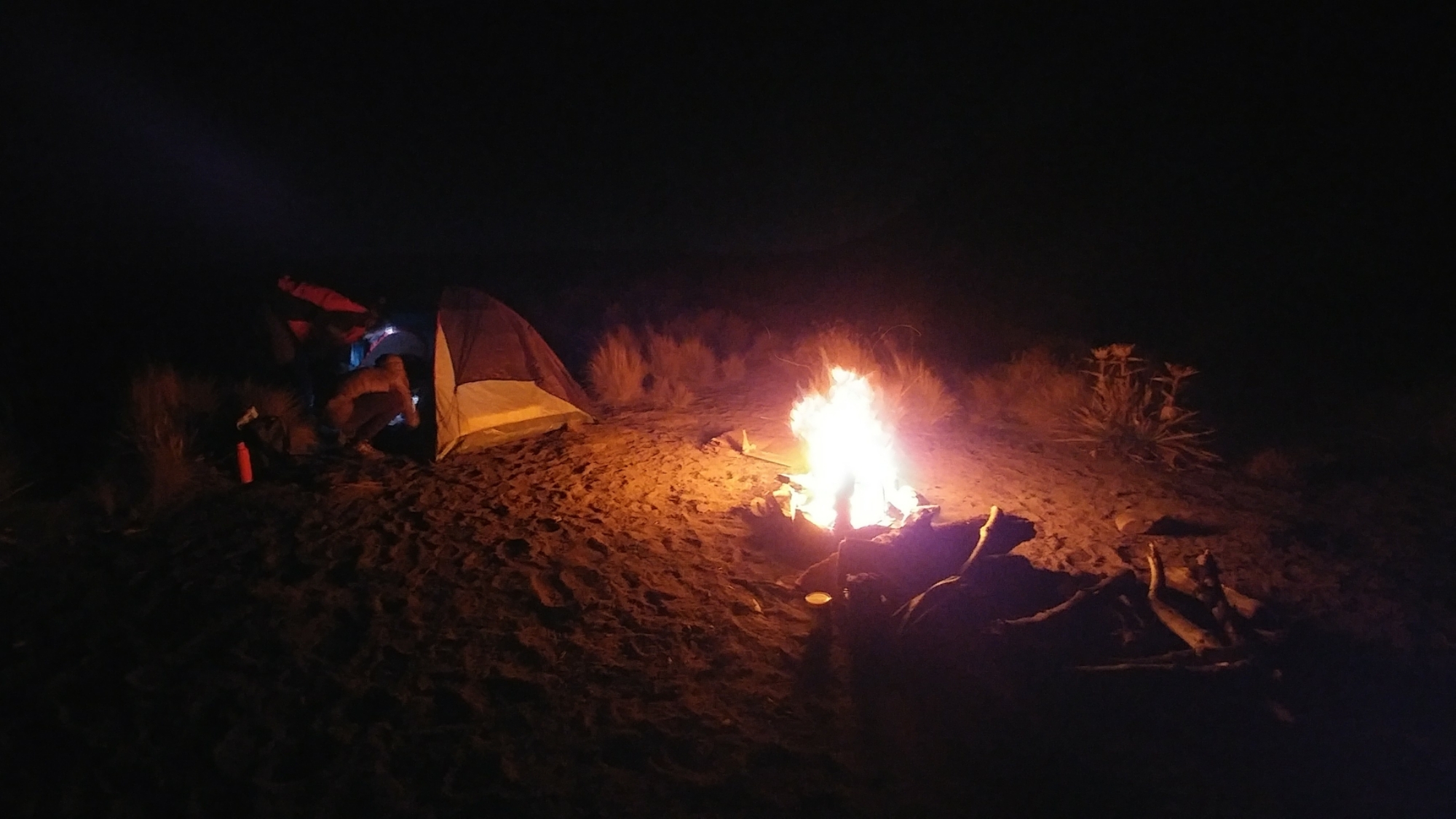
Aliah was from Quebec and met his girlfriend Isabel in Mazatlan; now they were taking the scenic route back to Mexico City. As camping inside the nevado was prohibited, we pitched our tents on a patch of sand outside the crater rim.
 We ventured up to the rim to catch a glimpse of the nevado’s famed sun and moon lakes. As the sun was setting behind El Fraile, the volcano’s highest point, details at the bottom were hard to make out. Aliah and Isabel did yoga poses over on an adjacent summit while I soaked up the remaining few minutes of daylight.
 We met back at the campsite after they descended into the crater to get water while I went the opposite way, to the forest, to scavenge for firewood. The evening was spent having what felt like the quintessential Mexican experience: cooking over a open fire in the dry, high mountains underneath a canopy of stars. The only thing missing was our donkeys tied up nearby.
28/01/17 – Toluca to Mexico City to Home
 We endured a freezing night in our tents, which was little surprise as we were perched high on the side of a volcano. Aliah immediately got a fire going as I jogged around in circles trying to restore circulation in my limbs. The next challenge was defrosting the Nutella jar…
When the sun peeked over the crater, it was like a godsend. We finished off our haphazardly conceived, but delicious, camp granola, struck down our tents and headed up to see the lakes one last time. With the sun at our backs, the Sol and Luna lagunas displayed their respective hues, set in a landscape uniformly yellow with variations of orange, brown and red. Again the volcanoes of Mexico suggested the features of another planet.
 As we were all headed to the same destination, we split on the taxi to Toluca, caught the bus to Mexico City, then they helped me navigate the subway to the airport. It was nice spending the last two days with a couple hip, friendly strangers to whom I related in a surprising number of ways.
I returned to the airport accompanied by a sense of accomplishment and pride. I thought back to how I felt when I’d landed twelve days prior: how heavy my bag was; how embarrassed I was to speak Spanish; how worried I was about getting killed or robbed.
Now I was back, filthy, sunburnt, clothes caked in a layer of dust, with three Mexican volcanoes under my belt. I strutted through the airport feeling like the fucking man.
…
After going through security came the last and most important objective of my trip to Mexico: purchasing high-quality tequila.
The duty-free shop appeared and welcomed me as though I’d entered the pearly gates of agave heaven. After spending a half-hour discussing the science which distinguishes an anejo from a reposado, I made off with a bottle of sweet, smooth, amber-colored Herradura which spent two years aging in a Jack Daniels cask.
I boarded the plane, stashed the tequila and reclined into my seat. I’d not only survived this adventure, better yet, I had a great time and achieved every goal. I’d traveled to Mexico for its mountains but was leaving with a bit of a crush on the country itself.