Turning up the volume and reducing the velocity: that’s been the theme of this week. My mindset has shifted to training more concertedly for the demands of the Mont Blanc 80K which is three months away. Lately I’d been stuck in a rut – of only running ~20km and climbing ~1000m during my “long runs” – which I’m glad I broke free from this week with a sufferfest up Rundle followed by Sulphur. Conditions remain unseasonably mild and relatively dry and springlike, save for a recent powder day which made my ascent of Rundle a little more tiring than usual. Weekly total: 83km/4889m vert
03/12/15 – Sulphur – 1h54m/18.4km/870m
Super fast splits; quickish to TH (24m); then, didn’t seem fast but must have been steady and consistent to summit (44m); then a fairly short break on top (4m); then a steady sprint down the trail and back to my apartment (42m). Felt great pre-run as I’d taken the previous couple days off to rest tight ITBs and felt elated afterwards.
03/13/15 – Grotto – 2h11m/6.6km/860m
Should have done nothing, or cross-trained, but took the opportunity to drive to Canmore and scope out the direct trail up Grotto Mountain, which I’ve never done before. It felt cold leaving the car in my short shorts but was soon slogging shirtless up the steep singletrack. The lower part of the trail was good, the upper part was very loose and braided and a combination of factors sent me the signal that today wasn’t the day to bag the summit. I cut my losses and headed down. Loose subalpine terrain like that is fun (or whatever) but not very conducive for race training purposes as I don’t expect to encounter trail (or lack thereof) like that in Chamonix this summer or anywhere else.
03/18/15 – Rundle + Sulphur – 7h14m/39km/2400m
Ran up Rundle trail from home and postholed up the Dragon’s Back to the summit. Snapped a few pics, slammed my knee on a rock buried under deep snow, then stumbled back down the ridge and headed home. Switched into dry shoes and headed up Sulphur. Sulphur slog was labored to say the least. My longest run and most vertical yet this year. Peep the Movescount data for this trip here.
03/20/15 – Tunnel/Hoodoos/Tunnel – 2h29m/19km/759m
Ran up Tunnel via main trail, descended and swung around back and ran rolling singletrack along the bench to Hoodoos viewpoint. Then ran back, dropped down toward the river and caught the start of the loose, steep goatpath that ascends Tunnel’s southwest shoulder. Pounded it hands-on-knees to the top, then descended via the main trail back to town and thence to my apartment.
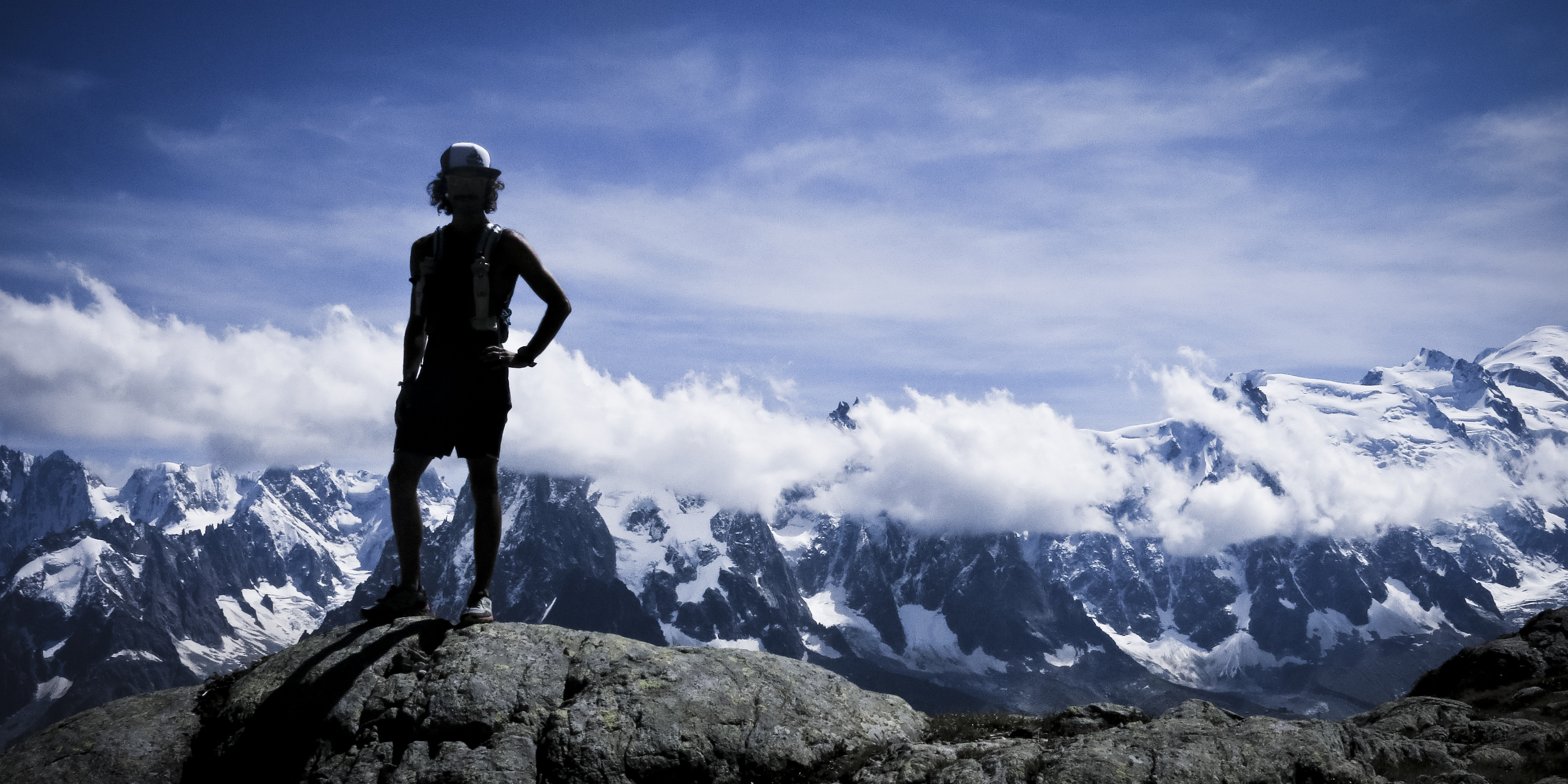
Basking in Mont Blanc-ness atop Brevent one week before CCC.
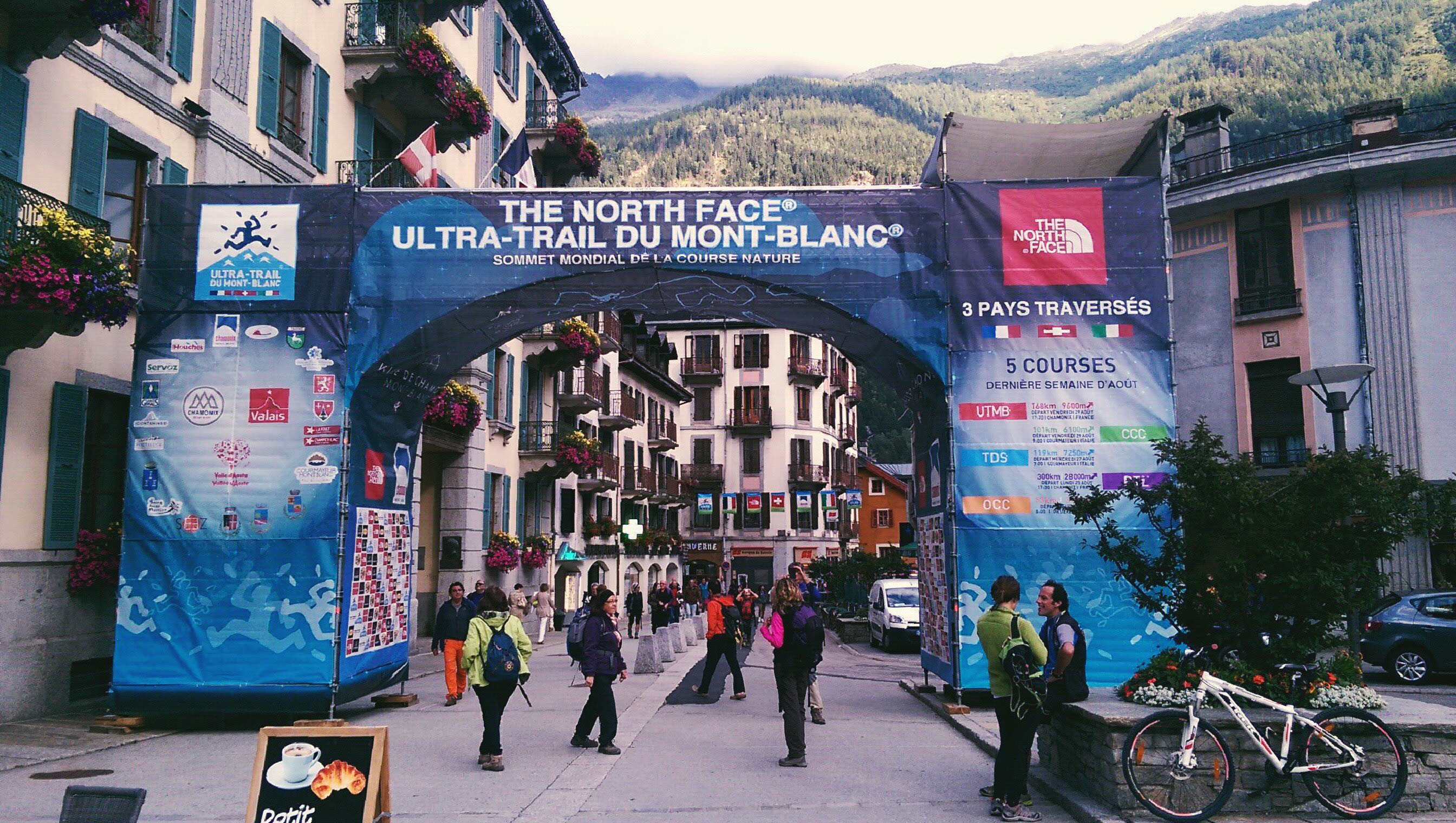
Ten thirty-five to forty-eight ten: the range of my emotions, in vertical metres that is. I’ve long postponed my CCC race report, admittedly overwhelmed with the idea of trying to cram everything I saw and did into one blog post. My week in Chamonix, then taking part in one of the races of the North Face Ultra Trail du Mont-Blanc was a sensorial whirlwind, a rich, multifaceted experience which leaves me disoriented and not knowing where to begin… At the beginning, I suppose. In this post I’ll briefly detail my adventures leading up to CCC 2014 and leave the “race report” (and all the pics from the race) for the next post.
My preparations to run CCC — once the “little sister of the UTMB” and now one of the most prestigious 100km races in the world — began two years ago. I don’t know why I thought running this race would be a good idea, but expected it to be epic, scenic and cater to my particular strengths (i.e. slogging up mountains, then running down them). I raced around on fifty miles of ski runs and mountain bike trails at Meet Your Maker in Whistler, BC last summer to garner two qualifying points needed to register. Fast forward six months and by some grace of God I won the lottery and became one of a few Canadians among 1500 others toeing the line in Courmayeur on August 29th.
First day in Cham… the stokage runs high.
Fast forward another six months or so. My first day in Cham; the stokage runs high. I set my alarm for seven but didn’t get up till ten probably because I was so jetlagged. I scrambled out of bed and took the gondola up to Brévent (2525m) for an alpine trail-running traverse to L’Index/Flégère for a panoramic viewing of Mont Blanc’s many glaciers and pinnacles. Along the way I visited Lac Cornu and Lac Blanc, somehow missing Lacs Noirs. If the Aiguilles Rouges range somehow replaced Banff’s Sulphur Mountain overnight, I wouldn’t be a tad bit upset…
Aiguille Verte (4122m) and the Drus, seen from near L’Index on Brevent.
Descending from Le Brévent on right, back down toward Planpraz gondi station as the first stretch of my run.
Mont Blanc, looking real fine… Summit is snowy high-point on right.
Seeing kids in the mountains always makes me a little misty because I’m so passionate about them now and never saw a true mountain until my twenties. Instead I used to love aimlessly scrambling and jumping to and from the boulders in cottage country, an activity which has directly influenced my trail-running now. This dude was doing much the same except the backdrop isn’t Lake Huron, it’s the tallest mountain in western Europe. He wasn’t too concerned with the scenery, however; his animated scrambles kept him busy most of the time at Col Cornu.
Lac Cornu (2560m).
Lac Cornu (2560m).
Some of the awesomer trail running I’ve done.
Lac Blanc, the normal colour I expect from an alpine lake: blue raspberry kool-aid 😛
^The crowd goes wild: start of PTL 2014, downtown Chamonix. Before this trip I neither knew nor cared about PTL but now recognize it as the more-badass, more-underground version of UTMB and has risen to the top of my ultrarunning bucket list. The Promised Land of Chamonix, seen from Signal Forbes on a rainy day.
On day three, I threw on my running pack and headed up to Balme for some Swiss pasture style trail-running. No, I didn’t need more cowbell; there was plenty to be had up there booting around on white ribbon singletrack to all the little knolls and viewpoints overlooking Chamonix on one side, Trient on the other. At last, I hit up the Albert 1er hut at the base of the Glacier du Tour as the clouds cleared to reveal the Aiguilles du Tour and Chardonnet. Tres awesome!
Heading up to peep the Croix Fer (iron cross) in Balme area, Switzerland.
Looks like fun trail-running to me… Mont Blanc on left, Chamonix down below.
Peeps chilling at the Croix Fer, amongst the clouds.
Looking down to the village of Vallorcine from near the Tête de Balme (2321m).
Skies clearing over Chamonix.
Trail-runner glory shot atop Aiguillette des Posettes (2201m). Mont Blanc and Chamonix in the background.
The fun way back to town…
Old man chilling out, overlooking Vallorcine.
assumed everyone in Europe was an uber-fit trail-runner; even here I can take the suggested times and cut them in half.
Dejeuner at the Col de Balme kitchen… Sure beats energy gels and granola bars.
“Let a sleeping dog lie”… THAT’S WHAT I’M FREAKING DOING!
Looking across the Glacier de Tour toward Aiguille du Chardonnet, presently hidden in the clouds.
Pinnacle-like Aiguille du Tour (3529m).
Aiguille du Chardonnet (3824m) reveals itself just as I reached my hypothermia-threshold shirtless beside the Glacier du Tour.
Looking across the valley from above the Albert 1er refuge.
Cows and chairlifts, something you don’t see at Sunshine Village, har har har…
You know you’re a versatile runner when you can gorge yourself with Indian food, miss the last bus, then run 6km home with a loaded pack (containing all your mandatory equipment), a bag of groceries in one hand and boxed dinner in the other, pausing occasionally to let my meal “express itself”. Casual running at its finest!Getting into rest and recovery mode: overlooking Chamonix from Mont Lachat.
One day before my race, I sought out a low-intensity activity to exploit the nice weather and went up the Aiguille du Midi cablecar for sweet views, zero exertion required. After snapping about a million pics of the Mont Blanc massive and surrounding eye-candy, I strolled into a tunnel with my shades on and saw two scrawny alpinists walking towards me. It took a moment for my eyes to adjust and as they passed we gave each other a quizzical stare: it was Kilian Jornet and Emilie Forsberg! I walked past all giddy and awkward, saying nothing, but then thought to myself that I should at least go back and shake their hands, or something. I pulled a U-turn and raced back, searching all the logical places they might be. Nowhere to be found. Puzzled and a little disappointed, I gaze out across the ocean of mountains and what do I see? Kilian and Emilie charging down a steep snow ridge other parties are shuffling along roped together. I was in awe, and felt fortunate that I spotted these ultrarunning idols in action instead of just mulling around town, for example. An auspicious experience which got me super-stoked less than twenty-four hours before my race!
Longest unsupported cablecar in the world… I’m not terrified!
Hang ten, Mont Blanc. Hang Ten.
Cham and the Aguilles Rouges range.
Practicing my race-day shudder… I mean stare.
Piton Sud.
Mountaineers mountaineering.
Parents, watch your kids.
Helbronner gondi to the Italian side of Mont Blanc.
BORING! A 57km backcountry trail run from Mt. Assiniboine to Sunshine Meadows through some of the finest subalpine scenery the Rockies has to offer. A cold, cloudless morning at Mt. Shark trailhead turned warm and sunny as we cruised along buttery singletrack, climbed a couple gnarly passes, ran out of water when we needed it most and narrowly dodged thunderstorms, experiencing the full spectacle of mountain weather without bearing the brunt of it. In the course of our trip, we crossed the BC-Alberta border six times, courted a few aches and pains, incessantly made fun of each other, and crushed nearly 60km of Continental Divide eye-candy in one sitting. Like I said, pretty boring…
What’s generally treated as a two- or three-day backpacking excursion was one long but overly scenic backcountry jog for us. I really had no idea we were in for such a slog up to Citadel Pass more than halfway through the run, but perhaps it’s better we didn’t know… I’m sure Pat and Jordan loved it 🙂
Our first views of Assiniboine.
3618m Mount Assiniboine and Magog Lake seen from near Assiniboine Lodge.
Departing the Assiniboine area and heading north toward Og Lake.
Awesome rock outcroppings, manicured-looking turf and smooth singletrack trail…
Heading toward a constriction in the meadow along Og Creek.
Hey, they call this area “Valley of Rocks”… I wonder why that’s the case.
Jordan and Patrick descending towards Og Lake.
Descending rocky trail to probably reascend again somewhere else
Getting faded, with Assiniboine and our previous 40km in the picture behind us.
At the top of Citadel Pass, marching toward Quartz Hill in centre, with glaciated Mount Ball on right.
Rock outcropping on the side of Citadel Peak, seen as we crossed Citadel Pass from BC back into Alberta.
Jordan running towards Quartz Ridge, our final climb of the day.
Jogging through a lush meadow toward our last climb up Quartz Ridge on right.
Circling Howard Douglas lake on our way up Quartz Ridge.
In awe, or “aww shit, we still have really far to run”?
Jogging the white ribbon which leads back to Sunshine Meadows from the top of Quartz Ridge. Spectacular trail running!
What began as a bluebird day became quite rainy and stormy, everywhere other than directly above us
“Did I say fading, I meant 5K to go!” Patrick says as he sprints toward a thunderhead which looks like a volcano erupting overtop of Bourgeau.
It was awesome to experience the spectrum of mountain weather all around us, but without actually getting soaked by rain or hit by lightning. We certainly got drizzled on, blasted by wind, and cautiously marched toward the top of Citadel Pass with an extremely active thunderstorm hanging over Fatigue Mountain to the north of us, but for the most part the weather made for a more complete experience of this landscape than a bluebird day would have offered.
If anything could prepare my eyes for the scenery I’ll see running around Mont Blanc in The Ultra-Trail du Mont-Blanc CCC next month, it might be this: A 60km out-and-back tour of Mount Robson to peep the Rockies’ tallest peak firsthand.
What was intended to be an “analogue run” two weeks prior to Trailstoke 60K Ultra in Revelstoke turned into a glorious day of warm sun and cool breeze; more roaring waterfalls than I can count on one hand; neon blue tarns with creaking glaciers flowing into them; buttery subalpine singletrack; chossy, exposed ledge running and sprinting up lateral moraines like some dude in a North Face ad; a little hands-on-knees grunting; about three litres of unfiltered mountain water and a near-miss with momma bear and cub. Just another day running around in the Rockies half-clothed 🙂
Splits:
0:31 Kinney Lake
2:45 Berg Lake
5:01 Snowbird Pass
7:57 Berg Lake
9:38 Kinney Lake
10:23 Berg Lake Trailhead
Trail running opens the doors to seeing more in less amount of time; what is generally treated as a two- or three-day backpacking trip then becomes a daytrip for the long-distance trail runner.
Buttery-smooth packed-stone trail dropping down from Land Of A Million Waterfalls (my own name for it) to the river flats near Berg Lake.
Berg Lake and the Rockies’ tallest mountain, Mount Robson (3954m), towering two vertical kilometres over the tarn.
Standing above Snowbird Pass (2719m) on the BC-Alberta border, looking down on the NE face of Mount Robson and the valley I just ascended. I am now 30km from my vehicle and feeling fairly fresh, but trying to avoid thinking about the next 30km I need to travel to get home…
View of Mount Robson and Whitehorn from my little perch above Snowbird Pass.
Looking down to the Coleman Glacier on the east side of Snowbird Pass. The pass and ridge I ascended to get here can be vaguely seen on left.
Looking down to Mount Robson’s huge north glacier during my descent from Snowbird Pass.
Back to the soft, cruisy trails of the Berg Lake area which my legs appreciated for the last 20km back to the car. Awesome trails and awesome scenery!
On the summit ridge of Mt. Lady Macdonald, 9 hours after starting the three-peak, 38km, 3500m vertical Canmore Triple Crown.
My second go at this masochistic little scrambling endeavour first devised by two buddies of mine in 2012 and reconfigured by myself into a 100% bipedal effort around this time last year. The Triple Crown is a one-day ascent of Mount Lady Macdonald, the east end of Mount Rundle (EEOR) and Ha Ling Peak, a grand tour of the city of Canmore, Alberta totalling thirty-eight horizontal kilometres and over 3500 metres (puke!) of accumulated vertical gain. Assuming I was stronger this year than last, I had definite intentions to beat my old time (12 hours), but both trips certainly involved their fair share of lollygagging, selfie-taking, and sitting on my ass eating sandwiches whilst cursing the mountains.
I crushed my old time, sweltering in inferno-esque temperatures (to me, anyway), chugging back melted snow with my running pack fully prepared for winter-mode if necessary. It definitely wasn’t necessary. I hope to return to this project some day with a lighter pack and a little less time devoted to taking pictures of myself to put up a truly speedy FKT. Until then, I’ma hit up this foam roller and drink some water 🙂
Splits: (7:45am start from Rocky Mountain Bagel Co., downtown Canmore)
1h03m – EEOR trailhead (TH) | 6.4km | 372m ↑ | 6.4km total
1h12m – EEOR summit | 2.3km | 884m ↑ | 8.8km
0h51m – EEOR TH | 2.4km | 872m ↓ | 11.2km
1h03m – Ha Ling summit | 2.9km | 801m ↑ | 14.2km
0h43m – Ha Ling TH | 2.9km | 808m ↓ | 17.2km
1h54m – Lady Mac TH | 11.1km | 469m ↓ | 28.3km
2h13m – Lady Mac summit ridge | 3.9km ↑ | 1182m | 32.7km
1h02m – Lady Mac TH | 3.3km | 1151m ↓ | 35.5km
0h17m – Bus stop | 2.5km | 118m ↓ | 38.0 km
This year I don’t need to carry the front page of the National Post with me to prove I bagged all these mountains; now I have a fancy GPS watch which tells me all sorts of nerdy details about my trips
View out my window at 5:45am on the morning of my Triple Crown trip.
Steep Ha Ling Peak, mountain #2 of the day, seen across Whiteman’s Gap during my ascent of the East End of Rundle.
Standing on top of the east end of Mount Rundle, 2590m, two hours and fourteen minutes after departing downtown Canmore.
View of one of Rundle’s subpeaks, arguably a cooler feature of Rundle than it’s actual summits. Evidence of spring avalanches was everywhere although the scramble routes on each of the Triple Crown peaks were pleasantly dry.
Eating a ProBar in the rock shelter (which offers mininal shelter) on top of Ha Ling Peak, 2408m, four hours and nine minutes after leaving downtown Canmore. Mighty Mount Temple is in the background at far left looking closer than it actually is.
A gorgeous day in Canmore, seen from the top of Ha Ling Peak. One thing I love about the Triple Crown and long-distance mountain running in general is the different types of locomotion required over the course of the day. After ascending two rather steep peaks in a fashion similar to climbing stairs by skipping every other step — for a vertical kilometre and a half — one is then required to actually run eleven kilometres across the valley and slog up the biggest peak of them all 😐 Who came up with this stupid idea, anyway?
Looking from top of summit #2, across Whiteman’s Gap to the east end of Mount Rundle, summit #1 of the day.
Top of Mount Lady MacDonald, 2605m, eight hours and fifty-seven minutes after first leaving downtown Canmore at 8am. It is now nearly 5pm and fairly windy. Whereas I hit my low point ascending Ha Ling Peak last year (peak #2), this year I felt strong until I got to Lady Mac and then staggered up the mountain, stopping every few minutes, lightheaded, to heave back oxygen like I don’t do this on a regular basis. The glory of physically challenging endeavours is when that quality that one needs to do what one’s trying to do — drive, will, “mojo”, physical energy, period — is utterly drained, yet one pushes on regardless. This realization has been both a gift and curse, as I now realize that no matter how weak and shitty I feel, I probably, actually, have the ability to push on indefinitely. This makes copping out a little harder to justify.
The knife-edge ridge which leads to the true high-point of Mount Lady Macdonald… I like this ridge when it’s dry and when winds aren’t so gale-force. I’m only a hundred and fifteen pounds and this Arc’teryx shell is like a wingsuit on me
View looking back down Mount Lady Macdonald’s SE ridge which, at the moment I take this photograph, I despise very, very much. Most of the ascent up Lady Mac consists of really good trail until you reach the “bench”, site of the old teahouse (middle of picture). The final push to the summit ridge is loose and exceedingly tedious: one of my least favourite sections of mountain I’ve personally experienced. Smart of me to least the worst for last?
My trusty New Balance MT110W’s which got me through this silly trek. I think they liked it better in the soft, clean snow of winter; not so keen on this scree stuff…
I often do epic things in the mountains right before going home to Ontario to visit so I am somehow imbued with epicness and the spirit of adventure in a place I associate with an almost suffocating sense of banality. I don’t think this practice really counts for much, except perhaps to stroke my ego, but it’s not like I boast about my adventures and once home my focus became firmly centred on visiting friends, spending time with my family and revisiting old hiking haunts in my newfound trail-running style. I also ran a rather flat 10km trail race at Terra Cotta conservation area which, by some stretch of the imagination, serves as a qualifier for a spot in the elite division at the Canadian Mountain Running Championships, a 12km/1200m vertical sprint at Kicking Horse Ski Resort, Golden, British Columbia three weeks from now which I’ll also be attending.
The place that helped me “train” for hiking in the Yukon and the Rockies (not really), Forks of the Credit Provincial Park, Caledon, ON.
Though the Terra Cotta course was a modest one, it was a good, early test of a new dimension of running I want to explore: speed. In the past I’ve always focused on distance, building the overall length of my long runs week after week, trotting along through the backcountry for thirty, forty, fifty kilometres at a pace intended to keep me from sweating too much and prematurely burning too many calories. Now I wanna do the same thing, faster. Misunderstanding how the race’s timing worked, I snuck into the back of the first wave seconds before the starting buzzer and shot off in a high-velocity tiptoe through the winding roots which covered the trails of this course. I finished in a respectable (for me, anyway) 19th place out of 260 runners. Not fast enough to qualify for the mountain running team, but I have different racing plans on my agenda this summer, anyway. Peep the Movescount data for this race here.
One hell of an approach: 30km from Banff to Canmore to climb Ha Ling in its worst snow conditions all year. 45km total, 1300m vert.
My calves feel like they’ve been used for boxing practice. Getting out for long runs rather inconsistently, yesterday’s thirty kilometre run to Canmore and ascent of Ha Ling Peak in the deepest and slushiest snow conditions I’ve ever encountered it in means I’m a little sorer than usual today. To reach Canmore I jogged along the Rocky Mountain Legacy Trail, which is much flatter, paved and runnable than what I’m used to running on, so I wasn’t really sure if the benign-ness of my chosen route would destroy me over twenty-five kilometres.
After a big dump — which we just received a weekend of — I’m used to powder piling up on Ha Ling at treeline, resulting in, say, a one-hundred metre stretch of waist deep sugary snow to plow through, with the rest of the peak wind-scoured and barren. Yesterday, however, I found the whole alpine zone of the peak caked with knee-deep isothermal snow from treeline to summit, with a crust that would barely hold your weight with one step and would break through on the next. Of course, what did I really expect at 4pm in the afternoon on a sunny day after, oh, our biggest single snowfall of 2013-14? I rank that as my most arduous ascent of Ha Ling, ever.
Descending Ha Ling wasn’t too difficult; I gained so much momentum on the slushy, muddy lower part of the mountain that I almost ran over Adam Campbell, 5Peaks Race Series organizer, Arc’teryx-sponsored athlete and one of Canada’s strongest male ultramarathoners. We shared gripes about the post-holing nightmare that was the top of Ha Ling and chatted about trail-running, races and the revered New Balance MT110 over a few kilometres through the boulders of Grassi Lakes before my descent into town. A highlight of my day. Peep the Movescount Move for this trip.
In other news, looking forward to giving these guys a spin… La Sportiva Anakonda mountain running flats.
Never thought I’d ever actually summit these guys, let alone run all over town to do it, or bag multiple in one day…
In the spring of 2011, while traveling to the Yukon, I stopped and took a picture of Canmore’s mountains with my phone and sent it to my buddy Jay, saying, “Yeah, I think this is where we wanna be.” For months we’d discussed setting up shop in Canmore (because living in Banff seemed like a pipedream) and spending all our free time bagging every summit possible. I pictured myself like some old-school mountaineer with wool alpenstocks and a long ice axe toiling up these snowy mountainsides amid snow squalls and spindrift…
Although the steep rock faces seen in the top picture possess heaps of technical climbing routes, I never suspected the backs of these mountains had routes that could be walked (or run) up in a matter of hours. Three years later, Banff is my home and the Canmore mountains I’d once fantasized about climbing are now routine trips I do in the dead of winter, when my eyelids are freezing shut, or on days when I don’t really feel like hiking or running at all. The thought of actually standing on top of these peaks once seemed incredibly out of reach, let alone doing it in a style that is fast, light and aesthetic or linking together multiple peaks as per the Canmore Triple Crown, which I wish to repeat this season.
I’m grateful every day for this landscape, the passion it inspires and what it has molded me into.
Overlooking Banff’s Massive Range from Sulphur Mountain’s upper gondola terminal
Last week ushered in springlike temperatures in the Bow Valley, allowing me to strip off the leggings and try my hand at a couple different — variably slushy or icy — front range mountains.
The week began with my first time doing repeat runs up Sulphur Mountain (37km, ~2000m vertical) and my first outing wearing shorts this season! I’ve long seen Sulphur X2 as a fairly gnarly training day but both climbs were super easy and neither was any worse than the other. The stellar weather also let me to test out gear donated by Lululemon Athletica Banff for my go at Ultra Trail du Mont Blanc’s CCC this summer. Loving the superlight fabrics of the Metal Vent Tech and Surge Short, closest thing to running in a loincloth possible. And running in a loincloth is my life goal 😐
Looking over the top of Mount Lady Macdonald at a huge drainage notorious for flooding the town of Canmore last spring.
Thursday and Friday after my Sulphur repeat, I had some spare time to run/scramble — and I really just can’t help myself — so I hit up a couple of dry, windblown front range peaks. Thursday consisted of a 6km/800m jaunt up Heart Mountain bordering the prairies; Friday was a 10km/1250m ascent of Mount Lady Macdonald overlooking Canmore. Although free from deep snow, I found the trails on each incredibly icy due to recent melting during the day and freezing during the night. The clear, slick water-ice emphasized the dullness of my Microspikes and my need to seek out a file and sharpen those bad boys up. Goddamn shoulder seasons, first gnawing apart my YakTrax and now dulling my Microspikes…
All in all, last week I did four mountain runs in three days, back to back to back (to back). I ran about 53 kilometres and ascended over 4000 metres. Like I said, when conditions are prime, I just can’t help myself.
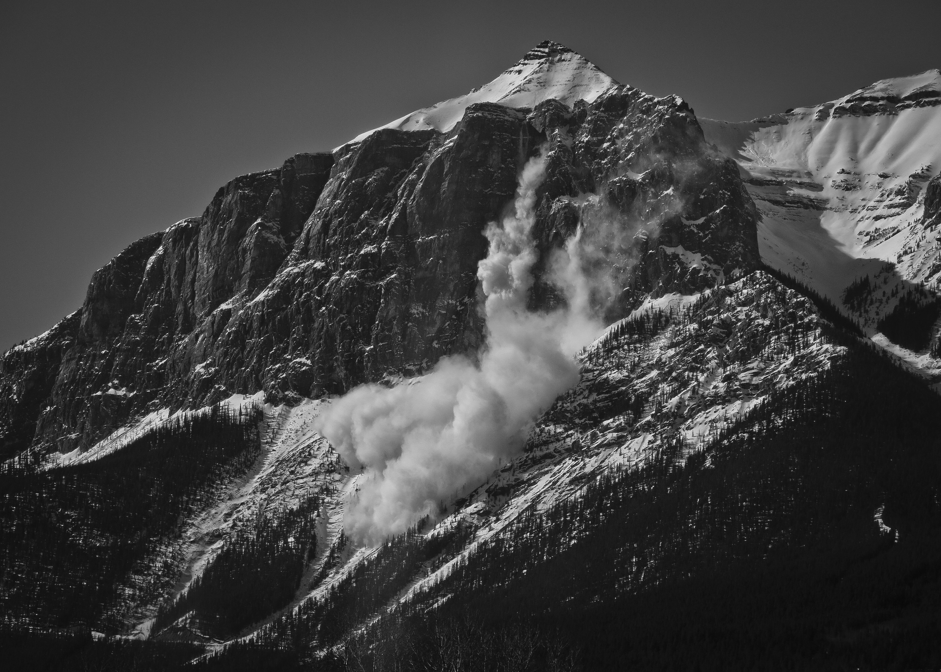
Ridge leading to the true summit of Lady Mac. Might give it a couple weeks before I give this a try…Witnessed avalanche control on the east end of Mount Rundle while paying for coffee in the drive-through.
The snow gods have been blessing the Bow Valley lately. Tunnel Mountain, Banff, AB.
A near-PR to the top of Sulphur plus my first “long run” in a while, combining a trip up and down Tunnel also. The second climb kinda sucked but I ran the whole way and felt fairly fresh and pain free. So far, this season I must be doing something right…

 03/18/15 – Rundle + Sulphur – 7h14m/39km/2400m
 03/20/15 – Tunnel/Hoodoos/Tunnel – 2h29m/19km/759m